Friday, July 4, 2014

Monarch Butterflies in the Siskiyou Mountains

Got Milkweed?

Monarch butterflies that live east of the continental divide embark on a spectacular annual migration to winter roost sites in oyamel fir trees in the mountains of Michoacán, Mexico. They are the only butterflies to accomplish such a long, two-way migration each year, something more commonly associated with species like birds, wales, salmon or caribou. Unlike these other species, however, it takes three to four generations of monarchs to complete the annual migration. It is a multigenerational feat. Most monarchs only live a few weeks as adults during the migration, except for the last generation in the migratory process, the overwintering monarchs, which can live up to seven or eight months. Despite their seemingly fragile nature and their short lifespan, individual monarchs can travel hundreds to thousands of miles. Monarchs use the sun as their primary navigational tool, but according to a recently published paper in the journal Nature Communications, they are also capable of using an internal magnetic compass on cloudy days.  

It is less known that monarch butterflies that live west of the continental divide, including monarchs that migrate through the Siskiyou Mountains, overwinter in various groves of trees along the central and southern California coast where they are generally protected from freezing temperatures. Monarchs aggregate in more than 25 roosting sites along the California coast each winter, but their overwintering habitat is threatened by coastal development.

 According to the World Wildlife Fund (WWF), "In the most recent migration, fewer of the orange- and red-winged monarchs made it to the end of the journey than ever before. The monarch butterfly population in Mexico was the lowest ever since 1993 (the year scientists started to monitor monarch butterfly colonies), according to research just released by the WWF-Telcel Alliance and the Monarch Butterfly Biosphere Reserve Office of the Mexican government. The research shows a 43.7% decrease (nearly three acres) in the total amount of forestland occupied by monarchs in and near Mexico’s Monarch Butterfly Biosphere Reserve. The research was conducted over several weeks in December 2013 and the decrease is in relation to December 2012 research."

The WWF lists the monarch butterfly as "near threatened," or a species that is likely to qualify for a threatened category in the near future.  The International Union for Conservation of Nature calls the monarch migration an endangered biological phenomenon.
 
Graphic by Journey North
Population of monarchs at the overwintering grounds in Mexico 

Monarch population chart for monarchs living west of the continental divide that overwinter in California

In May, 2014 both Jackson and Josephine Counties in Oregon passed ballot initiatives that will ban the planting of GMO crops. The landslide victory in Jackson County shows that most people don't want GMO crops planted in Jackson County. The measure passed 65.9% Yes to 34.1% No. In Josephine County the results were 58% to 41%   These two measures will greatly improve the chances of monarch recovery in the Siskiyou Mountains.

Threats to Monarch Butterflies
  • Loss of milkweed
  • Logging of overwintering grounds in Mexico
  • Climate change
  • GMO crops
  • Pesticide use
  • Coastal development of overwintering grounds in California 


Photo essay: The lifecycle of monarch butterflies in the Siskiyou Mountains


On May 15, 2014 I spotted two monarch butterflies fluttering around two separate showy milkweed (Asclepias speciosa) patches that my wife, Suzie, planted nine years ago. One patch is in our vegetable garden and the other in a native rock garden on the side of the road. Previously we had only seen one tattered monarch scoping out our patches, so this was a hopeful sign. When Suzie got home from work that day I told her what I saw and she immediately inspected for eggs. Sure enough, there were about fifty eggs combined on both the patches of milkweed.  Research has shown that a female monarch typically lays about 700 eggs in its lifespan, so this was not a huge number of eggs.


Monarch caterpillar eggs on milkweed
Monarch caterpillar eggs are very small


Monarch caterpillars are tiny and vulnerable when they first emerge.

Around ten days later the eggs started to hatch and an estimated 15-20 tiny, little caterpillars emerged. They were hard to spot because they hid within the plants and it was hard to keep track of them and know for certain how many there were.

When small the caterpillars stayed within flower buds.

The caterpillars eat the milkweed plant and grow bigger.


The tiny caterpillars got bigger as they ate the milkweed plant, mostly staying within the protection of the flower buds. They never denuded the plants, but rather took little chunks out here and there, allowing for the viability and sustainability of their host plant.


As they get bigger they are easier to spot.
Sometimes they eat the flower buds.


Some small caterpillars died of mysterious causes.


Over the course of a few weeks a number of caterpillars disappeared, but those that remained got bigger and fatter. Monarchs have natural predators, parasitoids, and parasites that can harm monarch eggs, larvae, pupae, and adults. It's a tough world for monarchs in their natural setting, and human impacts to habitat just compound the threats.

In just two weeks a caterpillar will grow and need to shed its skin five times. Each skin is called an instar. The stages of a caterpillar's life are referred to as the first instar, second instar, third instar, fourth instar, and the final fifth instar. We observed the caterpillars eating the skin after it was shed, as if it was a source of nutrition.
Hanging out on milkweed

Munching on milkweed

The caterpillars rested under the leaves
5th instar caterpillar

Monarch caterpillar hanging in "J" shape on June 23, 2014.

The caterpillar has attached itself with a cremaster and hangs in a "J" shape as it prepares to shed its old larval skin and begin the formation of the chrysalis.


Monarch in a chrysalis formed on June 24, 2014. 
The scientific name for the monarch butterfly is Danaus plexippus, a Greek term meaning "sleepy transformation." This reflects the species' metamorphosis.


Monarch on showy milkweed in May, 2014

 After its metamorphosis into a butterfly the monarch will eat, mate and lay eggs if it is a female. They will search out and find whatever milkweed they can. Monarchs will use any plant in the genus Asclepias, even cultivars of the native species.  The last generation in the migration will then head south to the California coast to overwinter and start the cycle anew as has happened for millennia.


Monarchs fall to the ground while mating. This photo was taken at the end of January at the Pismo Beach Monarch Butterfly Grove in California.


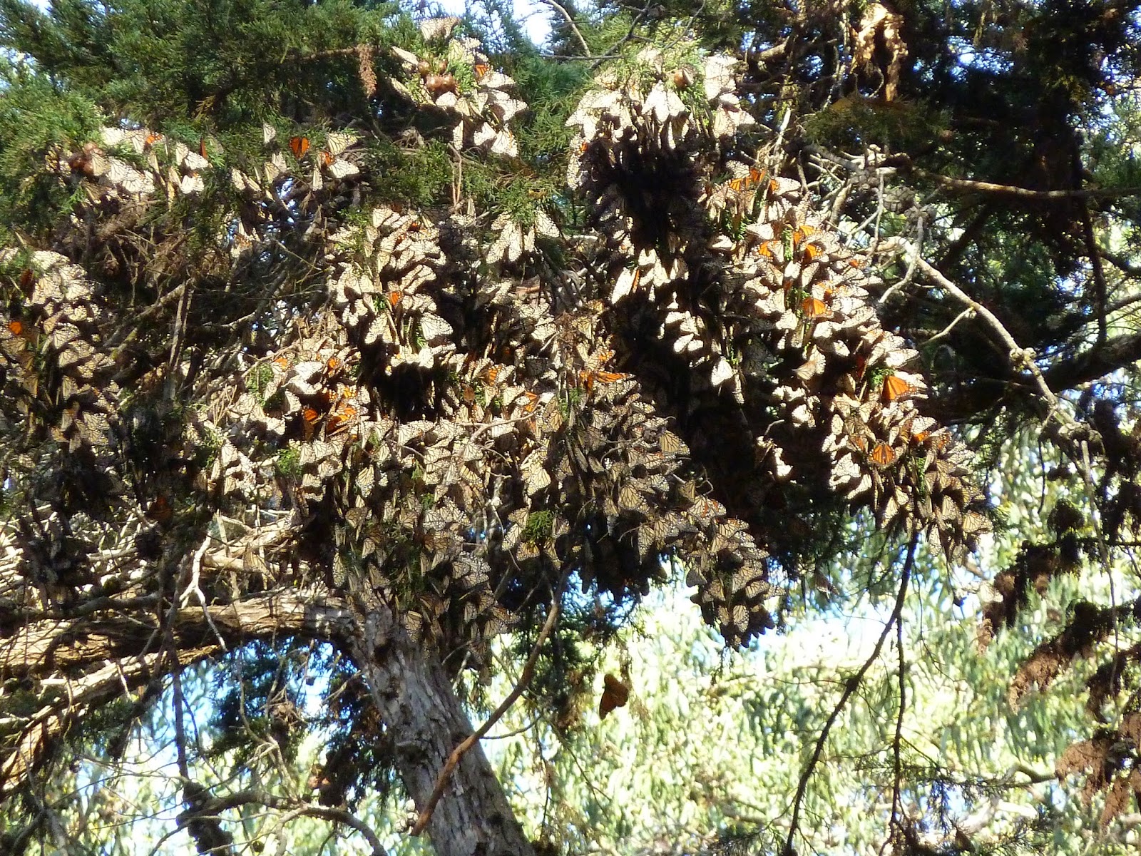
Monarch butterflies cluster together for warmth as they overwinter at the Pismo Beach Monarch Butterfly Grove in California. This colony is one of the largest in the United States.

For further information visit the following:

Journey North

Monarch Watch


Sunday, June 22, 2014

WILDFLOWERS AND WILDFIRES ON THE SISKIYOU CREST

The diversity and color of wildflowers responding to the 2012 Goff Fire is truly staggering. Before the fire much of the Siskiyou Crest was carpeted in dense stands of montane chaparral. Throughout much of the area the fire burned in a natural mosaic of high severity fire, burning off the chaparral and encouraging a lush growth of wildflowers. In this section of the Siskiyou Crest it is clear that wildflowers need wildfire; in fact, to bloom in such spectacular profusion they may need periodic hot fires.
Rock penstemon (Penstemon rupicola) blooming at the margin of the Goff Fire near Rattlesnake Mountain. There were about five other species of penstemon in the fire area on the verge of blooming. If you get out there within the next few weeks the floral display will be diverse and impressive. You will see a mixture of what is pictured in this post, along with more species of penstemon, fireweed, and innumerable Washington lilies made more stout and vigorous in response to the fire.
Blue gilia (Gillia capitata) carpets the Boundary trail in the burn area. Typically, before the burn, blue gilia was only seen in the occasional rocky bald or opening in this section of the Siskiyou Crest. It is now abundant in many portions of trail.
Fire dependant Knobcone pine (Pinus attenuata) seedlings are abundant in the fire area.

Indian paintbrush (Castilleja spp.) and Oregon sunshine (Eriophyllum lanatum) bloom in abundance in the fire area; some areas are so thick with Oregon sunshine that you can see the golden yellow hue from miles away. Both species have responded positively to the Goff Fire with large, robust plants, a profusion of flowers, and both will likely produce large amounts of seed this summer. Wildflower communities throughout the fire area are thriving.

 The rare Siskiyou daisy (Erigeron cervinus) appears to respond positively to fire, blooming in moist, rocky areas adjacent to Lonesome Lake. This species is found only in the Klamath-Siskiyou Mountains of southwest Oregon and northern California. 

 
Parish's nightshade (Solanum parshii) blooming in the fire area on the Siskiyou Crest. This species is strongly fire adapted and often associated with chaparral habitat. Considered relatively rare in Oregon, this species is more abundant in California, found growing all the way south into Baja, California.

Chinese houses (Collinsia spp.) are found in dense masses on thin, rocky soils throughout the fire area. They are especially abundant in the area between Rattlesnake Mountain and Figurehead Mountain. In this photo it can be seen blooming amongst the burned remains of chaparral species. In many places a fire mediated community of wildflowers can be seen blooming at the base of old, woody shrubs. When the shrub is burned off a robust growth of flowering, herbaceous plants respond to the lack of shrubby competition, and often fire generated germination and seedling recruitment is increased. 

Tritelia crocea blooming in the fire area near Rattlesnake Mountain
Dwarf purple monkeyflower (Mimulus nanus) blooming near Goff Butte. Large, dense populations can be found blooming in rocky scree within the fire area.


This Phacelia species is perhaps the most abundant flowering plant in the Goff Fire area. Vast stands of montane chaparral consumed by high severity fire have been transformed into flower fields dominated by Phacelia.  


I visited the Goff Fire area over the weekend of June 13-15 and what I saw was simply a snapshot in time. A new and exciting community of wildflowers is now beginning to bloom in beauty and abundance across this section of the Siskiyou Crest. The seasonal procession of wildflowers has birthed new displays of color and diversity, one floral community melting into another, as the season turns from spring to summer to fall. The ridgeline has currently reached a fire-generated climax of floral dominance; a successional community responding to the combined influence of natural disturbance, climatic variation and geologic bedrock. While I walked the crestline I found myself wishing I could return a week or two later to enjoy the many species still to bloom. In my mind I can imagine the vast populations of Washington lily, penstemon, and fireweed blooming from the rocky, charcoal tinged slopes as I write this article. The bloom is on and renewed each day with the rising sun.


Friday, May 30, 2014

THE STUDHORSE INCENSE-CEDAR


                         The Studhorse incense-cedar in the Condrey Mountain Roadless Area                              (See my head in between the two trunks?)


With its headwaters nestled in the eastern portion of the Condrey Mountain Roadless Area, Studhorse Creek flows north from the Siskiyou Crest. It is a land of dry meadows, corn lily fields, schist bedrock and spectacular ancient forest. The stream was named in 1855 following the Humbug War on the Klamath River. It was late July and a group of three Shasta Indians were visiting the community of Humbug Creek. During their visit the Indians had done some trading for a bottle of whiskey and proceeded to become intoxicated. As the Indians left the settlement a miner by the name of Peterson inquired as to how they had acquired the whiskey and attempted to take the bottle from the inebriated Indians. When the Indians refused, Mr. Peterson drew his revolver and shot one of them in the abdomen. The Indians responded by shooting and killing Mr. Peterson.

The next day a "volunteer regiment" organized to find the "guilty" Indians. They captured three Indians who refused to answer their questions and began forcibly taking them to Yreka for trial. Two of these Indians escaped from custody, while a third was brought to Yreka and released due to lack of evidence. The two escaped Indians, afraid of retaliation from the volunteers, returned to their tribe and formed a war party. That night they marched down the Klamath River from Little Humbug Creek to Horse Creek, killing eleven miners and burning many cabins before fleeing over the Siskiyou Crest.

In response the volunteer regiment indiscriminately killed twenty-five peaceful Indians along the Klamath River in retribution, including women, children, and elderly tribal members. The peaceful Indians were either shot, hung or thrown alive into mine shafts. Meanwhile, the fleeing war party, which had fled north, reached what is now called Donomore Meadows, atop the Siskiyou Crest, where they killed a Frenchmen named Donomore and a Portuguese miner named Silvee. Supposedly Silvee was at Donomore Meadows helping Mr. Donomore build a barn with the aid of Silvee's horse. The Indians attempted to take Silvee's stallion but apparently it could not keep up. They shot the horse with numerous arrows and left the horse for dead. A few days later local miners found the horse on the north slope of Condrey Mountain in a canyon they then referred to and named Studhorse Creek.


Studhorse Creek in the Condrey Mountain Roadless Area

Recently I made my way up to Studhorse Creek to explore the canyon and visit the Studhorse tree, a massive, old incense-cedar with the largest diameter in the world. Wallace Robinson and Loran Cooper identified the tree in 1947. It was officially measured by Oliver Matthews in 1954 and declared the largest diameter incense-cedar in the world. This enormous, old incense-cedar was later determined to be—or thought to be—two trees that fused at the base, rather than one stand-alone tree. This disqualified the tree from the champion tree register, but does not take away any of it majesty. Measuring nearly 13' Diameter at Breast Height (DBH) at its fused truck, the tree towers to over 140' tall. There are massive burls at the base of the tree and it forks into two very large trunks roughly 13' from the ground.

Enjoying the view from the Studhorse incense-cedar


Incense-cedar distribution extends from small, disjunct populations in northern Mexico at the southern extent of its range, to a stand on a rocky island in the Deschutes River at the northern extent of its range. Despite this vast distribution, the largest incense-cedar in the world are found in the Klamath-Siskiyou. Many large, old incense-cedar can be found in the Klamath-Siskiyou, including four of the five largest documented trees in the world, as well as the current champion tree found in Devils Canyon in the Marble Mountains Wilderness.

Measuring the Studhorse incense-cedar

Incense-cedar trees are extremely variable and can be found growing in harsh, rocky sites, in canyon bottoms or in meadow margins. Many of the largest trees are found in the little cirque basins atop each tributary of the Siskiyou Crest. The Siskiyous have many of these hidden gems that are relatively unknown and many yet to be found. Places like the Siskiyou Crest and the Condrey Mountain Roadless Area need permanent protection for many reasons, including some of the world's largest trees and most diverse conifer forests. The Studhorse tree and the forest that surrounds it should be protected from logging, road building and development as a portion of the Condrey Mountain Wilderness Area in the larger Siskiyou Crest National Monument. These proposed designations would preserve the connectivity of the west coast's most important land bridge: the Siskiyou Crest. Connecting the Coast Range to the Cascade Mountains, the Siskiyou Crest is a hotspot for biodiversity and a haven for wilderness habitat. For the wildlife and all the wild places in the Siskiyou Mountains, join us as we work towards permanent protection for this special place.  

Permanent protection is needed for the Condrey Mountain Roadless Area

Sunday, May 4, 2014

Siskiyou Field Institute Course May 18, 2014

Fire Ecology of the Red Buttes Wilderness

                                     
Fire Ecology of the Red Buttes Wilderness

Instructor: Luke Ruediger
Date: Sunday, May 18, 2014
Location: Meeting at Applegate Dam, carpooling to trailhead in the Red Buttes
Tuition: $55
                       email: institute@thesfi.org
                       phone: (541) 597-8530

Course Description
This course will use the 2012 Hello Fire as our classroom. The fire is a wonderful example of low to moderate intensity fire that has been allowed to recover naturally. Course participants will explore the old-growth forests of the Butte Fork Canyon. Topics covered will include fire management, wildland fire use, minimal impact fire suppression tactics, post disturbance response and recovery, as well as stand development and dynamics in mixed-conifer habitats.

Wednesday, April 2, 2014

Big Windy Fire Report

Big Windy Fire Report: Wildfire on the Wild Rogue
An analysis of fire effects, fire suppression impacts 
and management implications 
  
A view into the Big Windy Fire, looking down Howard Creek in the Zane Grey Roadless Area
From the introduction to the Big Windy Fire Report: 
     
On July 26, 2013 lightning crashed down on northern Josephine and southern Douglas Counties in Oregon, starting numerous wildfires in the Cow Creek and Rogue River Watersheds. Three small fires were lit in the tributaries of the Wild & Scenic Rogue River. These three fires—west to east—including the Calvert Peak Fire, the Jenny Fire, and the Big Windy Fire, all burned in relatively remote and inaccessible terrain. In early August 2013 these three fires were declared a “complex” with one extensive fire perimeter; later these fires merged, yet in some places never burned to the officially declared fire perimeter.

The fires, burning low and patchy, were busy doing what fires have always done: they burned fuel, sculpted landscapes, and turned biomass into mineral-rich ash. The fires burned in wild and roadless forest, partially cut, roaded terrain, and in managed plantation stands. One look at the fire severity maps will reveal square, red blocks scattered across the roaded landscape denoting high severity fire effects. These square, red blocks coincide with plantation stands created through clear-cut and heavy shelterwood logging techniques in the decades between the 1950s and 1990s. Another look at the more intact canyons and ridges demonstrates another pattern. Here you see a predominantly low to moderate severity fire with vast areas of unmanaged forest burning in the understory and large areas remaining entirely unburned within the fire perimeter. According to Bureau of Land Management (BLM) fire severity map, 90 percent of the Big Windy Fire Area either did not burn at all or burned at low to very low severity. Only one percent of the fire area experienced high severity fire effects, and the majority of this high severity fire is located in previously harvested plantation stands.

The fire would flare up occasionally toward a ridgetop, on a harsh exposure, or when the wind and the canyon lined up just right, making uphill runs. The brush fields, some of the live oak groves on steep gravelly soils, and most of the plantations were torching, while the ancient forests and unmanaged wildlands burned less intensely. The head of the fire smoldered to a stop as it approached more coastally influenced forest, never reaching closer than two miles from the western fireline. With the weather conditions changing and rain falling throughout the fire area, the incident command team began an intrusive and damaging suppression strategy of extensive dozerline surrounding nearly the entire fire area and beyond. On August 5, 2013 firefighting personnel also began a large-scale backburning operation, which included much of the area adjacent to Bear Camp Road and the Mt. Peavine Road. 

The Big Windy Fire at the mouth of Big Windy Creek
Active fire spread came to a halt as the backburning began due to high humidity, low temperatures, and a few days of periodic rain. Backburning operations were also stifled by unfavorable fire weather. Slowly the fire was subdued by weather conditions rather than the efforts of firefighting personnel and agencies, including five days of rain in August and eleven days of rain in September. At a cost of $27 million, the Oregon Department of Forestry (ODF) and BLM caused severe damage to the Wild and Scenic Rogue River, the Zane Grey Roadless Area and the widely supported additions to the Wild Rogue Wilderness. They poured money, fire retardant and water buckets on the flames, they bulldozed ridgelines of ancient forest, cut thousands of old-growth trees, and built log decks for the timber industry with emergency firefighting funds. Despite their efforts, it was natural weather conditions that allowed for containment of this fire, not fire suppression efforts. 

Read the entire Big Windy Fire Report

By Luke Ruediger
April, 2014 


Tuesday, March 4, 2014

MT. ASHLAND SKI AREA: STRUGGLING TO SURVIVE, FAILING TO EXPAND


A view into the proposed Mt. Ashland Ski expansion area in the winter of 2011. The lack of a deep snow pack this season has brought the ski resort to the brink of financial collapse, ensuring they won't have the funds to expand anytime soon.

       For many years now the Mt. Ashland Association (MAA), owners of the Mt. Ashland Ski Area, have proposed expanding their operation by building new ski runs and chair lifts in the McDonald Peak Roadless Area and the municipal watershed for the town of Ashland, Oregon. The expansion would include over 70 acres of new ski runs, clear-cut into old-growth forest at the headwaters of Ashland Creek. The area in question includes numerous rare plant species, including Henderson's horkelia (Horkelia hendersonii), the Siskiyou Mountains' only stand of Engelman spruce (Picea engelmannii), and the world's only population of the Mt. Ashland lupine (Lupinus lepidus var. ashlandensis). The forest is also home to the rare Pacific fisher. 

     Serious issues of slope stability, as well as impacts to water quality, connectivity and wilderness quality habitat would follow any development into the wild and fragile Middle Branch of the East Fork of Ashland Creek. With the ski expansion currently approved by the Forest Service and nearly all legal avenues exhausted, the only hope for a wild Mt. Ashland may be for the existing ski resort to either fail to generate the funds needed for expansion, or for the ski resort itself to go out of business, forcing the plans to be dropped all together. A timely natural catastrophe for the MAA could be more effective than all the efforts of environmental activists and organizations combined. If mother nature cooperates by refusing to snow, she could very well save the McDonald Peak Roadless Area from destruction. Unfortunately, the situation leaves me praying for drought and a low snow pack.

     As the Siskiyou Mountains wait for a significant winter snow pack, the high summits of the Siskiyou Crest remain virtually snow-free. Mt. Ashland is the highest summit in the Siskiyou Mountains, at just over 7,500'. As I write this blog post the mountain has a mere 16 inches of snow and the ski resort has yet to open for business due to the lack of snow. It seems possible that the resort will not open at all this season, and it has already surpassed the previous latest season opening of February 17, 1977. The situation has stressed the already marginal ski resort financially. General manager Kim Clark recently made the following comments, regarding the lack of snow on Mt Ashland, to the Ashland Daily Tidings: "It could potentially close the area. Could any business survive a year without income? We continue to watch our reserves dwindle." 

     Bad news for the ski resort is good news for the Siskiyou Mountains. The difficult financial situation demonstrates the resort's precarious existence and the mountain's relatively poor location for a downhill ski resort. Given the financial and climatic realities expansion should be out of the question, especially when the new runs would extend to significantly lower elevations. The Siskiyou Mountains' tendancy for extended drought and minimal winter snow pack has plagued the ski area now for 50 years, leading to three past bankruptcies. Climatic conditions have historically played a major role in the viability of the resort and will continue to do so in the future, especially as we feel the increasingly pronounced impacts of climate change.   

     Within the last couple years it looked as though the ski expansion would move forward. The MAA threatened to begin clear-cutting the new runs and develop the expansion area in a phased approach while they raised funds to implement the project piece by piece; however, this approach would leave the association vulnerable to an over-extension of financial resources, especially given poor winter snow conditions. The worst case scenario predicted by many expansion opponents could very well have come true during this time. The expansion could have been partially implemented, the roadless area heavily impacted, an ancient forest lost, and the ski resort bankrupt, leaving lasting and irreversible impacts to the McDonald Peak Roadless Area, the biodiversity and connectivity of the Siskiyou Crest, and the municipal watershed. Luckily this hasn't happened yet.

     Instead of full-fledged expansion the association implemented a series of "improvements" this summer and fall, including the development of a large number of new parking spaces, re-contouring of the beginner's run, and widening of the existing runs by logging many large, old trees. The project went nearly $200,000 over-budget and the MAA is currently trying to recoup losses with a fund raising campaign based on financial donations.

     The Mt. Ashland Ski Area has also sold over 2,500 season passes for the 2013-2014 ski season, yet have been unable to offer a single day of skiing to date. Each season pass costs $289.00, amounting to over $700,000 in gross revenue. With the mountain remaining closed many season pass holders are asking for a reimbursement of funds. The Ski Area, thus far, has refused to consider that option, instead they have chosen to pray for snow and hope the mountain will open in the near future. With the MAA strapped for cash and the snow simply not materializing it is likely that the proceeds from these season passes will be kept by the MAA, having a detrimental impact on pubic relations. 

     This year marks the 50th anniversary of the Mt. Ashland Ski Area. Now is the time for committed activists to continue their efforts; with the MAA vulnerable we must increase the pressure, advocate for a boycott, reimbursement of season pass proceeds, and question the very wisdom of expansion in light of the financial and climatic realities. Write letters to the editor, contact City of Ashland officials, encourage the Forest Service to re-analyze the ski expansion with the new information now available regarding climate change and the resort's financial instability. Finally, as strange as it may sound, pray for drought, the future of Mt. Ashland may depend on it.  

To read interesting articles about the Mt. Ashland Ski Area's financial difficulties and lack of snow visit the following:

Ashland Daily Tidings article on 3/8/14 

Bend Bulletin article on 2/12/14