Sunday, September 30, 2018

Klondike Fire: Fire Ecology in the Biscuit Reburn

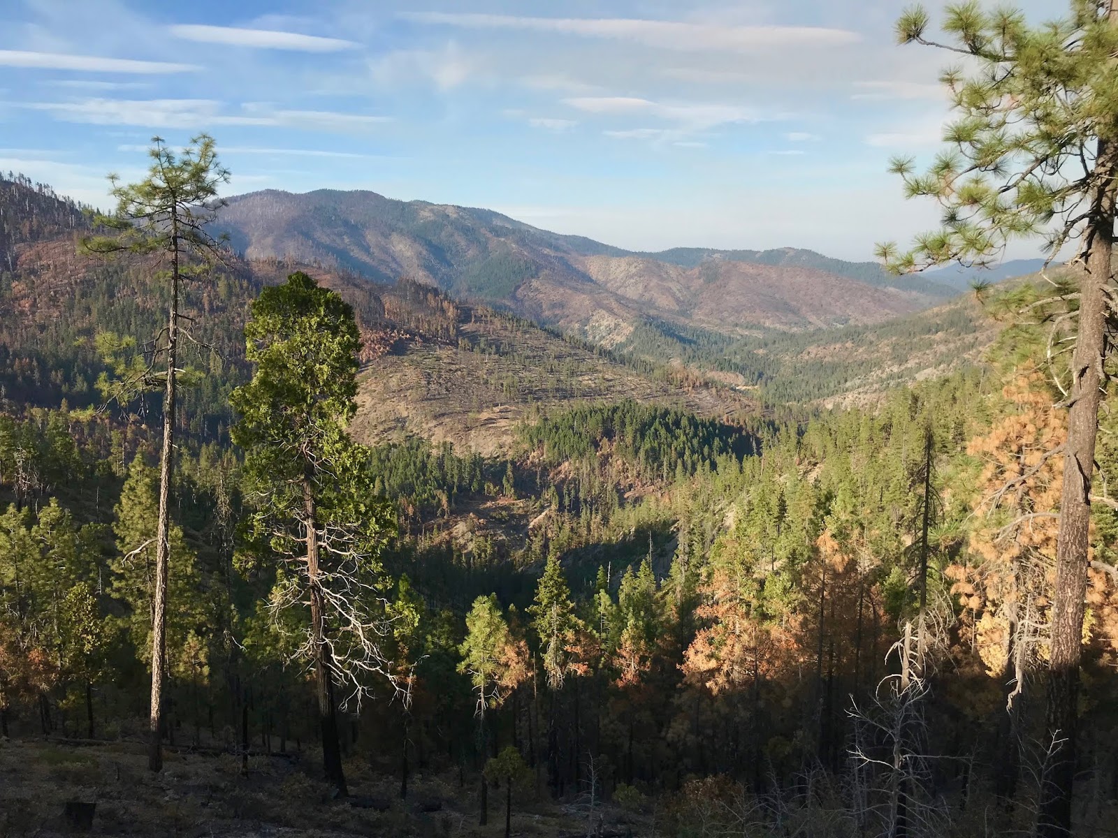
A view across the Klondike Fire from $8 Mountain Road to the Squaw Mountain Inventoried Roadless Area north of the Illinois River. Photo taken September 28, 2018.
The Klondike Fire began as a natural lightning ignition in some of the wildest, most inaccessible country on the West Coast. The fire started in the Klondike Creek canyon, deep in the Kalmiopsis Wilderness, within the vast Biscuit Fire footprint and in exceptionally rugged terrain. The Rogue River-Siskiyou National Forest aggressively attacked the fire, but could not contain the remote blaze due to a lack of resources, extremely rough and inaccessible country, and very real safety concerns for firefighting personnel. 

Cobra lily (Darlingtonia californica) burned in the Klondike 
Fire already has new, fresh vegetation.
Despite very aggressive fire suppression strategies that created significant environmental impacts and required an enormous investment of taxpayer dollars, the stubborn Klondike Fire still burns in the backcountry of the Kalmiopsis Wilderness and the surrounding Roadless Areas. Currently the fire is burning in the North Kalmiopsis Roadless Area deep in the canyons of Silver Creek, Indigo Creek, Horse Sign Creek and the lower Illinois River. 

Since the 2002 Biscuit Fire much of the region has been regenerating vegetation and rebuilding fuel beds. As vegetation has grown and ground fuels have built up, the Biscuit Fire footprint was finally ready to carry fire again. Some fires within the Biscuit Fire footprint, such as the 2013 Labrador Fire and the 2015 Buckskin Fire, were significantly moderated by the effects of the Biscuit Fire. Although suppressed, the Labrador and Buckskin Fires burned at mostly low to moderate severity and smoldered out in young patches of chaparral punctuated by rocky openings. 
 
The Klondike Fire as seen from upper Fall Creek with Pearsoll Peak in the distance.

In the past few years, however, larger fires have started to burn in the vast backcountry of the Kalmiopsis, including the 2016 Collier Fire, 2017 Chetco Bar Fire, and now the 2018 Klondike Fire. On particularly rocky slopes and harsh serpentine sites fire behavior has been significantly moderated by the influence of the Biscuit Fire and a lack of fuel continuity, even sixteen years later. In other locations, dense chaparral had formed and the fires burned with more intensity. In many cases, isolated islands of conifer forest and stringers of conifer habitat survived the fire, while the nearby chaparral burned. 

Fire-killed snags on the north face of Fiddler Mountain.
These snags are from the Biscuit Fire and they reburned in 
the Klondike Fire but many remain standing.
Many of the fire-killed snags from the Biscuit Fire still stand, even after the Klondike Fire, attesting to the relatively low intensity fire effects and the longevity of these important biological legacies. These snags are scattered within stands of green, living forest, underburned in the Biscuit Fire, or in ghostly, white swaths memorializing large, hot runs made during the Biscuit Fire. 

To this day, Biscuit Fire snags are providing habitat, building soils and have not significantly contributed to fire intensity. Despite dire predictions that stands not subjected to post-fire logging would burn at increased severity, neither the Chetco Bar or the Klondike Fire validated these concerns. Simply put, fuel loading is not the driver of fire severity, instead it is weather and terrain, with the most extreme fire events occurring when weather and terrain are in alignment or during heavy Chetco Effect wind.
Large swaths of Jeffery pine savanna near $8 Mountain burned at low severity in the Klondike Fire.

On its southeastern perimeter, the Klondike Fire burned from the banks of the Illinois River below Josephine Creek into mixed conifer forests and Jeffery pine savanna on harsh serpentine soils. The fire burned through fine grassy fuels in these savanna stands, burning at low severity and maintaining their open, spacious, and unusual character. The savannas rise gently at first, then climb into steep, rocky slopes of pine, rusty red serpentine outcrops, and tufts of chaparral. Higher on the slopes rich, mixed conifer forests reach to the stark, rocky ridges of the Chetco Divide.

The Klondike fire burned up Mike's Gulch, Alder Gulch and Hoover Gulch to Pocket Knoll, and from the north, up Fall and Rancheria Creek to Fiddler Mountain, Whetstone Butte and the region around Pearsoll Peak. Beyond Pearsoll Peak and Gold Basin Butte, the fire still burns in Salmon Creek above the Illinois River, sending a small plume of smoke into the blue, slightly hazy skies. 
 
A view across the Klondike Fire to the Illinois River and beyond.

At the headwaters of Fall Creek the Klondike Fire burned at mixed severity. Despite the vast brushy snag patches in upper Fall Creek, the fire was moderate and patchy. Much of the scattered forest that survived the Biscuit Fire, again burned mostly low and cool in the understory. As Fall Creek rises towards Fiddler Mountain, beautiful stands of fir, pine and cedar support robust populations of Brewer's spruce. This healthy Brewer's spruce population has made it through two large wildfires, mostly unscathed, and includes relatively large, mature trees, vigorous young trees, saplings and seedlings.

At the summit of Fiddler Mountain little has changed; the fire burned at mostly low severity, dying out as it climbed into the rocky headwall on the mountain's northern face. Groves of true fir, Doug fir, pine and Brewer's spruce grow among rock gardens, dense colonies of montane chaparral and bands of bare rock. 
A view north from the top of Fiddler Mountain into the Klondike Fire and the headwaters of Fall Creek.

The Klondike Fire burned to the Chetco Divide near Onion Camp, creating a complex mosaic of burned and unburned vegetation. Many large snag fields essentially underburned, maintaining the white snags while consuming the brush and regeneration below. 

In other locations, unburned vegetation snakes through areas that burned with intensity, as swaths of black reach up and over to the ridges. The fire snaked its way around the flanks of Whetstone Butte, dying out as it backed into the 2017 Chetco Bar Fire footprint and the Chetco River watershed. 

The Biscuit Fire burned across this same landscape in 2002, creating a forest of snags, referred to by scientists as "complex, early seral habitat." The habitat, although somewhat forbidding to the human eye, is exceptionally diverse and important for many wildlife species. The 2017 Chetco Bar Fire burned into the regenerating brush and young trees, turning the white, sun-bleached snags a rich, charcoal black. This summer fingers of the Klondike Fire burned over the ridge and into last year's Chetco Bar Fire footprint. Almost completely lacking fuel, the Klondike Fire naturally put itself out at the margin of last years burn. 
The Klondike Fire burned into the Chetco River watershed near Whetstone Butte, blackening the snags from the Biscuit Fire and burning a mosaic in the regenerating vegetation.

Although the 2018 fire season has been hard on human communities, it has not been so hard on the forests and canyons in which the fires burned. For much of the fire season heavy inversions and relatively favorable fire weather moderated fire behavior, creating highly beneficial low and moderate severity fire effects. 

When those inversion layers lifted and the wind blew, the fires responded, creating high-severity fire effects. In some places this converted mid to late seral conifer forest into complex, early seral habitat, and in other places the Klondike Fire burned through large swaths of chaparral with intensity. 
 
Low to moderate severity fire effects in the headwaters of Fiddler Gulch.

These mixed-severity effects, including the high-severity fire runs, will create diversity in structure and composition, while moderating future fire behavior. Wildfire is essential to the Klamath-Siskiyou Mountains and plays an important role in creating and sustaining the biodiversity this region is so well known for. In the case of the Klondike Fire, the reburn within the vast Biscuit Footprint will shape these regenerating forests for many years to come.

Despite the heavy smoke, intense public dialog and sensationalized media frenzy surrounding the Klondike Fire and the 2018 fire season, it appears to have been a highly characteristic natural event. Driven by wind, weather and terrain, the fires burned in a beautiful productive fire mosaic. When the smoke clears and the rhetoric dies down, many will visit the Kalmiopsis region and find the same, strange, fire-adapted landscape they know and love. Although the Klondike Fire itself was not uncharacteristically severe, it has been demonized by the media and by opportunist politicians. Interestingly, not much has changed in the wildlands, except the social and political climate that surrounds it.
.
A view across the Chetco Divide from Whetstone Butte to Pearsoll Peak. The Klondike Fire burned over the Chetco Divide from the Illinois River watershed and into the headwaters of Babyfoot and Slide Creeks. The photograph shows the mosaic of the 2002 Biscuit Fire, 2017 Chetco Bar Fire and the 2018 Klondike Fire. For the most part the snags were a product of the Biscuit Fire and both the Chetco Bar and Klondike Fires burned a diverse mosaic in the post-Biscuit regeneration.

Sunday, September 23, 2018

The Klamathon Fire

The Klamathon Fire burned lightly in upper Hutton Creek in the Soda Mountain Wilderness.

The Klamathon Fire: Tragedy, Devastation & Natural Fire Mosaic

The Klamathon Fire was many different things in different settings. At times, the fire was influenced by high winds and tragically raged through the community of Hornbrook, California, doing great damage as it burned homes and took one person's life. For all those affected, the Klamathon Fire was no doubt tragic and terrifying.

Yet at other times, the fire crept and smoldered, burning at mostly low to moderate severity in the backcountry of the Soda Mountain Wilderness. Ecologically speaking, the fire was beneficial and productive. The impacts to homes, infrastructure and public safety were significant and are important to acknowledge; however, the ecological benefits of the Klamathon Fire have been mostly overlooked.  
 
Skunkbush (Rhus aromatica) vigorously regenerating two months after the Klamathon Fire in the Horseshoe Ranch Wildlife Area.

To make things even more complicated, as the Klamathon Fire entered the backcountry of the Soda Mountain Wilderness, fire weather and fire behavior moderated dramatically, yet the BLM's damaging fire suppression response led to extreme environmental impacts. For those who know and love this wild region, the results were devastating.

The Klamathon Fire demonstrates the many difficult conundrums of wildfire in our region. In many situations a single fire can be tragic and devastating to human communities, but also ecologically beneficial at different times and in different locations within the fire. The Klamathon Fire is a prime example of the potentially complex outcome of wildfire.
  
Tragedy 
The Klamathon Fire began as an escaped burn pile on July 5, 2018 outside the town of Hornbrook, California, south of the Klamath River. Pushed by 35-40 mph winds and fueled by fine, grassy fuels, the fire jumped the Klamath River and began growing quickly in open woodlands, grasslands and along the riparian area of Cottonwood Creek. By afternoon, the fire was over 1,000 acres and had raced through the small community of Hornbrook, burning 31 residences, 3 non-residences, and 37 commercial buildings. The fire took the life of one resident in Hornbrook when his home was engulfed in flames as he tried to evacuate. A firefighter was also burned over in his engine, and he sustainied serious burns to his face and body. For the community of Hornbook, the Klamathon Fire was both deadly and devastating. In this sense, the Klamathon Fire was surely a human tragedy with long-lasting impacts.

The fire quickly jumped I-5, closing the four-lane freeway, and continued spreading north towards the Colestin Valley, west into the Siskiyou Mountains and east into the Soda Mountain Wilderness. Funneled by the mountain valley and pushed north by high winds, the fire spread quickly, and by July 7 had grown to 22,000 acres. Fire crews worked furiously to protect homes, private property and private timber as the fire raged through mostly private ranch land and timberland owned by the Fruit Growers Supply Company (FGS).

Devastation
At the northeastern fire perimeter the Klamathon Fire spread into the Hutton Creek, Slide Creek and Scotch Creek drainages, entering the Soda Mountain Wilderness and Cascade-Siskiyou National Monument. On the afternoon of July 7, the winds shifted, pushing the fire back onto itself and drastically minimizing fire intensity.
 
ODF fire crews bulldozed nearly 30 miles through the Soda Mountain Wilderness, including almost the entire Lone Pilot Trail.

Despite a significant moderation in fire behavior and spread, the Oregon Department of Forestry (ODF), working under the direction of the Medford District BLM, began bulldozing into the Soda Mountain Wilderness Area on old roads, and in some locations, creating entirely new dozerlines. ODF crews bulldozed across the Soda Mountain Wilderness over 20 miles from Pilot Rock to Agate Flat, reconstructing old, long abandoned roads. Crews built massive helicopter landing pads and "safety zones," bulldozing large areas where all vegetation was cleared to bare mineral soil. They also bulldozed streams, riparian areas, rare plant populations, archeological sites, and misapplied fire retardant directly into headwater streams.

Ironically, according to the BLM, roughly 80% of the Klamathon Fire was contained using hand built firelines. In fact, the vast majority of bulldozed "fireline" built in the Soda Mountain Wilderness was not used for fire containment and is many miles from any of the actual fire perimeter. Most of the routes opened with bulldozers were located mid-slope, winding in and out of watersheds, and climbing from canyons up to high ridges and then back down again. Simply put, this bulldozing was not strategic for firefighting objectives and was not done to provide direct fire containment, instead the dozer routes were built to facilitate convenient vehicle access through the Soda Mountain Wilderness, where motorized use is strictly prohibited. 
 
A large landing cleared with bulldozers in the Soda Mountain Wilderness near Camp Creek.

With complete disregard for the intent of the Wilderness Act and their congressionally mandated obligation to preserve wilderness character, the Medford District BLM approved the use of bulldozers in the Soda Mountain Wilderness, not for direct fire containment line, but rather to provide vehicle access throughout the protected area. In fact, the BLM has proceeded to approve routine vehicle access throughout the Soda Mountain Wilderness for over two months since the Klamathon Fire began, and even after it has been out.

They also built extensive dozerlines along the high ridge between Porcupine Gap and Bean Cabin, directly adjacent to, and in some places, crossing the Pacific Crest Trail. Crews bulldozed a large portion of the Boccard Point Trail, a former roadbed that had been fully decommissioned and revegetated to become a very popular wilderness trail. Nearly the entire Lone Pilot Trail was also bulldozed from Pilot Rock to Lone Pine Ridge. The impacts to the region's wilderness character have been great, but the ecological consequences, such as soil compaction, extreme sedimentation and surface soil erosion, increased stream turbidity, noxious weed spread, and the harassment of wildlife are also very concerning and perhaps just as long lasting. 
 
A bulldozer line on the eastern wilderness boundary near Agate Flat

The fire suppression tactics used within the Soda Mountain Wilderness during the Klamathon Fire are unprecedented in the Klamath-Siskiyou region. The implementation of Minimum Impact Suppression Tactics (MIST) during wilderness fires is typical in this region and is mandated in many Wilderness Management Plans. MIST includes the use of mule teams, foot paths, helicopters, and spike camps for access. These MIST tactics are routine in Wilderness Areas and most other National Monuments and National Parks. 

The option of MIST was available to the Medford District BLM. They simply chose to ignore their mandates to preserve wilderness character and instead bulldozed extensively across the wilderness area. The aggressive fire suppression tactics implemented within the Soda Mountain Wilderness by the Medford District BLM are not only unprecedented, but they have also likely been implemented in direct violation of the Wilderness Act.
 
A large helipad bulldozed in the Soda Mountain Wilderness south of Pilot Rock.

These suppression actions demonstrate a complete disregard for wilderness values by the Medford District BLM and ODF. They also demonstrate a need for corrective actions within the agencies. Specifically, land managers need to know that responsibly managing the Soda Mountain Wilderness is a requirement of their job. It is not an optional, discretionary decision, but rather a mandate handed down by congress. Wilderness designation is the dominant land use allocation and overriding management objective for the Soda Mountain Wilderness — it cannot be ignored.  

The designation of Wilderness is also a promise made to the American public, to protect our most intact, wild heritage. This promise was blatantly violated by the BLM during the Klamathon Fire. 
 
Crews bulldozed across the Soda Mountain Wilderness, including directly through many streams such as this stream crossing in upper Scotch Creek on the Lone Pilot Trail.

The devastation and long-lasting ecological impacts of the Klamathon Fire within the Soda Mountain Wilderness are all associated with the suppression actions approved by the Medford District BLM. The approval to use bulldozers was highly inappropriate and rests squarely on the shoulders of local BLM land managers. This decision is particularly troublesome given the proven effectiveness of handlines that actually contained and controlled the Klamathon Fire. The fact that hotshot crews utilizing handline actually contained this fire, demonstrates that the damaging suppression actions approved by local BLM line officers were not only an irresponsible violation the Wilderness Act, but they were also completely unnecessary.   

A Natural Fire Mosaic
Klamathon low-severity fire in upper Slide Creek in the Soda Mountain Wilderness.
 
Despite the human tragedy in Hornbrook and the ecological devastation of BLM's fire suppression response in the Cascade-Siskiyou National Monument, the Klamathon Fire burned in a highly productive and beneficial mixed-severity fire mosaic. For the forests, woodlands, grasslands and chaparral habitats of the region, the Klamathon Fire was a dynamic natural event with positive ecological implications.

The fire burned into the Cascade-Siskiyou National Monument and southern margin of the Soda Mountain Wilderness on steep south-facing slopes below the massive volcanic plug known as Pilot Rock. These slopes are naturally quite diverse and jumbled, with a wide variety of habitat types and fire regimes. 

Dry mixed conifer habitats dominated by ponderosa pine, Douglas fir and white fir grow in the upper elevations, mixed with beautiful oak woodlands, mixed hardwood habitats, grasslands, and dense chaparral. The lower elevation areas are extremely arid and desert-like, containing arid grasslands and juniper steppe reminiscent of the Great Basin.

While the Klamathon Fire was an accidental, unnatural ignition, its fire effects were characteristic and ecologically beneficial. The fire was fueled by wind and weather events, maintaining a natural, diverse fire mosaic on the dry ridges extending north from the Klamath River. Although fire severity mapping has not yet been released, it is evident that much of the fire burned at low to moderate severity, with small isolated patches of high-severity fire. 
Brewer's oak sprouting back after high-severity fire in the Hutton Creek drainage.

The high-severity fire effects often occurred in dense stands of Brewer's oak (Quercus garryana var. breweri). Brewer's oak is a variety of white oak genetically predisposed to low, short statured growth patterns. Brewer's oak thrives on natural disturbance such as high-severity fire and quickly responds with vigorous resprouting. Other locations that burned at high severity include chaparral patches and scattered conifer stands. 

Low-severity fire effects in oak woodland in lower Scotch Creek.
Many of the oak woodlands, conifer habitats and riparian areas burned in a beautiful mixed-severity pattern with predominantly low-severity fire effects.


Throughout the fire area conifer habitats are widely scattered, growing in isolated groves surrounded by oak woodland, juniper habitat, grassland, or rock outcrops. Many of these conifer stands contain massive old-growth trees and late-successional characteristics. They are found on more productive sites and mostly at higher elevations on north- and east-facing slopes. Nearly all these stands burned at low severity, burning off young regenerating conifers, shrubby understory species and ground fuels such as duff, downed wood and herbaceous fuels, while maintaining largely intact canopy conditions.

Habitat for western juniper is also scattered throughout the fire area. The species is largely found on rocky sites or in arid grasslands on south- and west-facing slopes. 

Much of the juniper in the area is widely dispersed with broad, open grown trees dotting the ridges and steep grassy slopes. Although they often grow in locations that are relatively fuel limited, western juniper is also notoriously flammable and many of these sites are extremely dry, exposed and windy locations. Many fire ecologists would have predicted significant juniper mortality, yet throughout the Klamathon Fire, western juniper burned at very low severity and the fire largely maintaining the ancient, open canopied stands scattered across Slide Ridge, Lone Pine Ridge and the headwaters of Hutton Creek. In many locations the low grassy fuels burned at extremely low severity with very minimal juniper mortality.
 
The majority of western juniper habitat in the Soda Mountain Wilderness, Horseshoe Ranch Wildlife Area, and Cascade-Siskiyou National Monument burned at low-severity in the Klamathon Fire. The fire burned in grass beneath open stands of western juniper.


Although the area had no recorded fire history and likely had not burned in over 100 years, the Klamathon Fire burned in a healthy mixed-severity fire mosaic. The fire maintained the complex patterns of chaparral, grassland, woodland and conifer forest found in this diverse and spectacular region. Although a tragedy in Hornbrook, California, the backcountry of the Soda Mountain Wilderness and the biodiversity of the Cascade-Siskiyou National Monument were enhanced by the regenerative flames of the Klamathon Fire. The fire provided the natural fuel reduction needed in an area that has experienced fire suppression for decades.

The Klamathon Fire will have numerous long-lasting effects. In the communities along the Klamath River and the Colestin Valley it will be remembered as a wind-driven fire with tragic human impacts. In the Soda Mountain Wilderness it will be remembered for the suppression impacts memorialized by bulldozer treads and bulldozed habitats. 

It is my hope that the the Klamathon Fire will be most remembered for how little it changed this landscape. The Soda Mountain Wilderness and its wild, diverse mosaic of habitats has been enhanced and maintained by the Klamathon Fire. Over these next few years, the Klamathon Fire will bring vibrancy and renewal to a landscape long starved of fire. It will also remain the same wild, beautiful landscape so many have fought for, but so few have fully explored.
The low-elevation portions of the Klamathon Fire in the Horseshoe Ranch Wildlife Area burned at largely low severity, maintaining the open-form juniper and patchy oak woodlands on the arid slopes of Lone Pine Ridge.


Friday, September 14, 2018

Smoke, Haze & Hypocrisy from the BLM


Late successional forest like this in unit 3-11 is targeted for logging in the Clean Slate Timber Sale. These fire resistant old forests will be heavily logged, "regenerating" young brushy vegetation that will significantly increase fuel loads and reduce fire resilience.
While smoke hangs in the air and fires still burn in the mountains around us, the Medford District BLM has been busy not just fighting fires, but also approving the first timber sales proposed under the 2016 Resource Management Plan (RMP). 

Meanwhile, the timber industry, the elected officials that serve them, and public land managers have been busy promoting rhetoric to support their push for "active management," a supposed panacea to smoke and fire, and a subtle euphemism for industrial logging disguised as "forest restoration."

According to the BLM, implementation of the the 2016 RMP, "will contribute to restoring fire-adapted ecosystems in the dry forest landscape of southern Oregon in increasing fire resiliency. The Proposed RMP will increase stand-level fire resistance and decrease stand-level fire hazards from current conditions." 

Yet, through the smoke, the haze, and the misleading rhetoric, the BLM has proceeded to approve the Clean Slate Timber Sale near Selma, Oregon and the Griffin Halfmoon Timber Sale near Howard Prairie Lake, just outside the Cascade-Siskiyou National Monument

This image shows the northern end of Howard Prairie Lake. The areas outlined in red are some of the units in the Griffin Halfmoon Timber Sale. Take note, they are some of the only late successional  forests in the area. These areas contain important wildlife habitat and the most fire resilient forests in the area surrounding Howard Prairie Lake. Also take note that extensive clearcut logging and deforestation from private and federal timber sales has reduced much of the existing forest cover to young plantation stands or grassland habitats. The areas in red will be logged to between 10%-20% canopy cover.
These timber sales have been designed to maximize timber outputs and reinstitute clearcut logging (rebranded as "regeneration logging") on public lands. Both timber sales were specifically approved to produce timber for the BLM's annual O&C timber quota, while admittedly increasing fuel loads and future fire severity. 

The Griffin Halfmoon Timber Sale has proposed to conduct 757 acres of "regeneration" logging, replacing mature forests with young plantation-like stands. Although some overstory trees will be retained, canopy cover retention could be as low as 10%-20% following the commercial logging operations. The majority of the harvest area would be replanted with commercially valueable species. These plantation stands have been shown to significantly increase fire severity while providing little habitat value. 

The Griffin Halfmoon Timber Sale will also remove 918 acres of Northern spotted owl habitat and an occupied nesting site for the great grey owl. According to the Environmental Analysis proposed commercial treatments, "would have negative effects to habitat suitable for use by fisher for denning and resting and for some fisher prey species due to the removal of trees and other vegetation."

The Clean Slate Timber Sale will log beautiful, diverse old-growth forest in unit 9-5.


The Clean Slate Timber Sale has proposed to eliminate 450 acres of Northern spotted owl habitat and 175 acres of late successional forest dominated by large, old, fire-resistant trees. This includes some of the last stands of old-growth forest in the watersheds above Lake Selmac and the Deer Creek watershed. Although the BLM claims these are not "regeneration" harvest units, they will be logged to between 25% and 35% canopy cover with up to 30% of each unit consisting of small clearcuts called "group selection harvests." 

These group selection harvests will be planted like little plantations and will quickly become chocked in brush. The drastic canopy reduction will necessitate the removal of 2,085 large, fire resistant trees over 20" in diameter and will encourage the highly flammable regeneration of young trees, shrubs and sprounting hardwoods. 

Both timber sales propose to convert currently mature, fire resistant forest into young, regenerating forest that is both highly flammable and susceptible to high severity fire effects. Perhaps for this reason, both timber sales contain the exact same language in their Environmental Assessments regarding fuel loads and future fire severity. The BLM states, "For the first 1 to 5 years after harvest, these stands would remain a slash fuel type until the shrubs, grasses, and planted trees become established. After the establishment of regeneration, these stands would move into a brush fuel type. Brush fuel types are more volatile and are susceptible to high rates of fire-caused mortality. Stands could exhibit higher flame lengths, rates of spread and fire intensity. Fires started within these stands could be difficult to initially attack and control...For 5 to 20 years following planting, the over all fire hazard would increase in these stands."


All trees in this photograph, except the tree on the left marked with red paint, will be removed from unit 3-11 in the Clean Slate Timber Sale. The project will replace fire-resistant old trees with highly flammable young "regeneration." Current conditions in this stand are highly fire resistant.


These timber sale are neither fuel reduction nor forest restoration, but they are "active management," and they will actively make fires more severe and harder to control. After a summer of fire and smoke, the residents of southern Oregon should demand more from their public land managers. I'm not sure what makes me choke more: thick wildfire smoke or the hypocrisy of BLM timber sale planners who are making the situation worse.


-This article was originally published in the Medford Mail Tribune as an Guest Opinion on September 9, 2018 by Luke Ruediger from the Siskiyou Crest Blog and Klamath Forest Alliance


Wednesday, September 5, 2018

Klamath-Siskiyou Fire Reports: More Fires, More Fire Reports and a New Website

The 2018 Taylor Creek Fire as seen from the headwaters of Pickett Creek. KFA will be exploring this fire as part of a new Klondike and Taylor Fire Report.


Klamath Forest Alliance (KFA) would like to announce our new website highlighting the Klamath-Siskiyou Fire Reports. Our Klamath-Siskiyou Fire Reports track local wildfires, document their fire effects, and the environmental impacts associated with fire suppression activities. 

Since 2012, we have conducted detailed analysis and on-the-ground monitoring of ten separate fires throughout the Klamath-Siskiyou Mountains. We have utilized case studies in the Klamath River Watershed, the Wild and Scenic Rogue River, the Kalmiopsis region, in the Applegate Valley and on the Siskiyou Crest. All our fire reports can now be found in one place at: klamathsiskiyoufirereports.org

Our reports document a pattern of damaging fire suppression activities and beneficial wildfire effects on public lands throughout the Klamath-Siskiyou Mountains. We are the only regional environmental organization with a program specifically focused on the reform of fire suppression policy and the reduction of environmental impacts associated with backcountry firefighting. 
Large dozerlines were cleared in the Soda Mountain Wilderness during the 2018 Klamathon Fire. KFA will be highlighting the egregious impacts of fire suppression in the Klamathon Fire with the upcoming Klamathon Fire Report.

Fire suppression has quickly become one of the largest threats to our wilderness and roadless landscapes. Even protected areas such as Wilderness Areas, National Monuments, National Parks and all manner of Forest Service or BLM land can be subjected to damaging industrial fire suppression activities. 

Each summer our wildlands and conservation areas are being bulldozed, blown up with fireline explosives, doused in toxic firefighting chemicals, "snagged" along roads and firelines, backburned, and degraded through fire suppression activities.

The 2018 fire season has been particularly active in southwestern Oregon with fires burning throughout the region. These fires have burned through some of our most cherished wildlands, including the Kalmiopsis Wilderness, Siskiyou Wilderness, Soda Mountain Wilderness and the Cascade-Siskiyou National Monument. Fires have also burned in recreation areas west of Grants Pass, Oregon on the Rogue River, Illinois River, Taylor Creek, and Briggs Creek. 
Low-severity fire burned through large portions of the Soda Mountain Wilderness and Cascade-Siskiyou National Monument in the 2018 Klamathon Fire.

While these fires have burned mainly remote, backcountry areas, they have also burned into or adjacent to rural communities. Portions of the fires burning adjacent to communities and in the most remote backcountry have been managed under the same aggressive, full suppression response, leading to severe fire suppression impacts in some of our most intact, protected landscapes. 

For example, the BLM bulldozed 20 miles of dozerline in the Soda Mountain Wilderness and at least an additional 20 miles in other sensitive portions of the Cascade-Siskiyou National Monument, including along the Pacific Crest Trail. Forest Service Botanical Areas on the Siskiyou Crest were also bulldozed during the Hendrix Fire, and fire managers have approved dozerlines in wilderness areas more during this summer's fire season than in the last twelve years in Oregon and Washington combined.   
Beneficial mixed-severity fire effects in the Taylor Creek Fire.
The impacts of backcountry fire suppression have intensified this summer in the Siskiyou Mountains. The Klamath Forest Alliance intends to continue our important and visionary work tracking local wildfires, documenting fire suppression impacts and advocating for the reform of fire suppression policy.

The Klamath-Siskiyou Fire Reports will be exploring the following regional wildfires as soon as the smoke clears. 
  • Klamathon Fire in the Cascade-Siskiyou National Monunment and Soda Mountain Wilderness. 
  • Klondike & Taylor Creek Fire in the Kalmiopsis Wilderness and surrounding watersheds.
  • Hendrix Fire on the north slopes of the Siskiyou Crest in the Little Applegate Watershed.
  • Natchez Fire in the Siskiyou Wilderness and surrounding watersheds above Takilma, Oregon and Happy Camp, California.  
 Please consider supporting our work with a tax-deductible donation! Now more than ever, the Siskiyou Mountains need fire savvy activists, with the courage to advocate for wilderness, wildfire and the reform of fire suppression policy. KFA is ready to address these impacts!


For more information: klamathsiskiyoufirereports.org