Nedsbar Timber Sale: Public Comment Guide
 |
| Unit 28-10B in the Bald Mountain Roadless Area. Trees up to 42" in diameter are marked for removal. The stand is naturally fire resistant with large well spaced trees, tall canopies, and minimal understory fuels. Logging will remove late seral characteristics while increasing understory fuel loads and fire hazards. |
The proposal would log some of the most scenic backcountry in the Applegate Valley along the proposed Jack-Ash Trail and within the viewshed of the popular Sterling Ditch Trail. It would also log forest directly adjacent to our communities in the Little Applegate and Upper Applegate Valleys, impacting the scenic quality of our properties and the view from many of our homes, as well as the region's bourgenoning recreation-based economy, wildlife habitat, wildlands and the beauty of the valley we love.
Fortunately, local residents, the Applegate Neighborhood Network (ANN) and the Community Alternative Working Group joined forces to create a more responsible, sustainable, and fire-wise alternative. Known as Alternative 5 in the Environmental Assessment, the Community Alternative would retain higher levels of canopy cover and large, fire resistant trees, while reducing fuels, prmoting forest health and producing a sustainable amount of timber.
The BLM has fully analyzed our community-based alternative and acknowledged that it meets the "purpose and need" of this forest management project. Alternative 5 is also consistent with the mandates of the Applegate Adaptive Management Area that was designated to encourage collaboration, innovation and community involvement in public land management planning and implementation. Please consider writing a comment to the BLM. Comments will be accepted until August 1, 2016. Comments can be sent to: blm_or_md_mail@blm.gov
Below is an analysis of impacts associated with the BLMs Alternative 4, in comparison to the Community Alternative, Alternative 5.
Fire/Fuels:
 |
| Fuel increase associated with commercial thinning. |
The BLM will also be removing many large, fire resistant trees that are the cornerstone of fire resilience and are most likely to survive the effects of a summer wildfire. These large trees are also particularly important for wildlife and contribute to the scenic qualities of the Applegate Valley.
Finally, Alternative 4 proposes to significantly reduce canopy cover levels and remove large, fire resistant trees in many of our most intact, fire resilient forests. Many of these stands consist of large, old trees with fire resistant characteristics such as closed canopy conditions that suppress shrubby understory fuels, thick insulating bark, high canopies and sufficient space between live trees. The stands are naturally fire resistant and are the most likely locations on the landscape to sustain low to moderate severity fire effects in a summer wildfire scenerio. The relative abundance of intact fire resistant forest contributes directly to our area's fire resilience. Logging these stands will increase fuels and fire risks, potentially encouraging high severity fire effects.
Nedsbar Community Alternative, Alternative 5:
In treated stands, the Community Alternative, Alternative 5, will retain adequate levels of canopy cover to address forest health concerns, suppress shrubby understory fuels and reduce the likelihood of extending fire season by drying treated stands. Alternative 5 will also retain all large, fire resistant stands in our remote and unroaded wildlands. Alternative 5 is also the only alternative to propose the use of prescribed fire to more effectively reduce understory fuels and restore low intensity fire to long unburned areas. The Community Alternative will reduce fuels, maintain fire resistant stands, protect large, fire resilient trees and begin to restore fire to ecosystems in need.
Unroaded Areas:
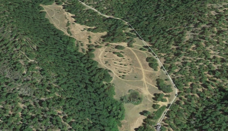
 |
| Alternative 4 proposes new road construction through these beautiful oak woodlands in the Trillium Mountain Roadless Area. The road would be built to access the uncut forest in units 26-20 and 27-20 on the northern slopes. The road would be built on the ridge in the center of the photograph. |
BLM's Alternative 4:
The BLM is proposing to commercially log nearly 1,500 acres in the Nedsbar Forest Management Project. Of this total, 72% or 1,086 acres are proposed in citizen identified roadless areas including the Buncom, Bald Mountain, Boaz Mountain and Trillium Mountain Roadless Areas. These are the last intact ecosystems in the foothills of the Applegate Valley and were recently proposed by Senator Wyden as a large Back-Country Primitive Area. In response to the proposed protection of these areas, the BLM proceeded to target them for logging before they could be protected. Many of the stands proposed for logging are late-seral or old growth stands that provide exceptional wildlife habitat.
The BLM is also proposing to build 3.2 miles of new road to access commercial logging units. BLM's Alternative 4 will build 2 miles of new road across the western face of Trillium Mountain and in the riparian reserve of Lick Gulch in the Trillium Mountain Roadless Area. This new road would sever the roadless area and badly damage the areas habitat connectivity, scenic qualities, hydrology, wildlife habitat, riparian habitat and native plant communities, while increasing the potential for unauthorized OHV use.
Currently these unroaded areas provide important wildlife habitat, harbor intact plant communities, sustain old-growth forest habitats, and offer solitude and non-motorized recreationa opportunities to local residents and visitors. These important values will be degraded by the proposed logging in Alternative 4.
Nedsbar Community Alternative, Alternative 5:
No new roads will be constructed under Alternative 5. The Community Alternative will protect unroaded habitats and the important values they provide. Proposed logging treatments will include roughly 200 acres within unroaded areas, but these treatments will retain all large trees and adequate canopy cover. These units will be located at the edge of unroaded areas with a few hundred feet of existing BLM roads. Their primary purpose is the creation of roadside fuel brakes intended to aid in the containment of wildfire or future prescribed fires. The effect will be an increase in forest health and fire resilience, yet the intact nature of these stands will not be compromised.
The Community Alternative proposes to eliminate 19 units on over 800 acres in unroaded area that are proposed for logging in BLM's Alternative 4.
Recreation:
 |
| The view from the Sterling Mine Ditch Trail across the Little Applegate River Canyon to units 26-20 and 27-20 proposed for logging in the BLM's Alternative 4. One mile of new road would be built in the Trillium Mountain Roadless Area to facilitate logging these uncut forests. |
BLM's Alternative 4:
The BLM has proposed logging 57 acres of intact old-growth forest on the proposed route of the Jack-Ash Trail. The Jack-Ash Trail is proposed to extend from Jacksonville to Ashland, Oregon and is poised to become a recreational hotspot for residents of southwestern Oregon and visitors to the region. The proposed logging units are located within one of the trails wildest sections in the Bald Mountain Roadless Area. Trees up to 42" in diameter have been marked for removal.
BLM's Alternative 4 proposes to log numerous units directly across from the Sterling Mine Ditch Trail. These units are predominantly located in the Trillium Mountain Roadless Area, an area that currently appears completely undisturbed. The majority of these units would be logged to 40% canopy cover, which would make the logging units very prominent and disruptive to the trail's viewshed. At least 25 units would be highly visible from the Sterling Mine Ditch Trail.
Nedsbar Community Alternative, Alternative 5:
The Community Alternative would protect the viewshed of the Sterling Mine Ditch Trail. Only 4 units would be visible from the Sterling MIne Ditch Trail, but these units would reduce canopy cover far less drastically that proposed in the BLM treatments, making the units less visible and more naturally appearing.
The Community Alternative proposes no logging in the Bald Mountain Roadless Area, eliminating the impact of old-growth logging on the Jack-Ash Trail.
In a era of diminishing opportunities to hike in areas unmarred by logging, road building and other industrial impacts, it is vital to retain the natural characteristics of the Applegate landscape for the economic importance of our growing recreational economy.
Northern Spotted Owl Habitat
Alternative 4 would impact Northern Spotted Owl (NSO) habitat and complex, late seral forest habitat by "removing" or "downgrading" NSO habitat. Removing habitat means that habitat conditions following logging operations have been degraded to the extent that NSO will no longer use the area for nesting, roosting and foraging (NRF) or dispersal. Downgrading habitat means that the quality of habitat following logging operations will be less useful to the owl than it was prior to logging treatments.
For example, habitat currently, identified as suitable for nesting, roosting and foraging would be "downgraded" to dispersal, meaning that the habitat conditions would no longer support nesting, roosting, or foraging habitat and will only function for NSO that are "dispersing" or migrating through the area. Dispersal habitat can be downgraded to "capable" habitat, meaning it is currently not useful to the NSO, but the soils and climatic conditions could support the complex forest that in turn supports the NSO.
BLM's Alternative 4 proposes to remove 109 acres of NRF habitat and 217 acres of dispersal habitat. The proposal includes 269 acres of NRF downgrades to dispersal habitat. In total, 595 acres, or 40% of the commercial logging acres are proposed to have negative impacts on the Northern Spotted Owl.
Nedsbar Community Alternative, Alternative 5:
Alternative 5 would protect and promote high quality NSO habitat by deferring many of the most complex, old forest habitats from logging treatments. Habitat conditions would be maintained in harvested units by retaining canopy cover levels at between 50% and 60% for the majority of uniti, as well as retaining all large, old trees. This is an important component of the Community Alternative because it is important for the NSO that its habitat is protected within treated areas.
Although the Community Alternative Working Group developed the alternative with guidelines to protect NSO habitat, the BLM analysis of the Community Alternative, Alternative 5, has shown a supposed downgrade of 26 acres of NRF habitat. We have requested information regarding where these supposed downgrades will occur in the Community Alternative, but we have not yet recieved a response from BLM.
BLM's Environmental Analysis shows that NRF downgrades and removals are nearly 15 time more prevalent in BLM's Alternative 4 than in the Community Alternative, Alternative 5.
New Road Construction:
BLM's Alternative 4:
Alternative 4 proposes 3.24 miles of new permanent road construction and 1.28 miles of temporary road construction. According to BLM nearly 1/4 mile of new road would be built in the bottom of Lick Gulch, potentially creating significant levels of sedimentation. Road reconstruction would take place on 4.45 miles of road. Alternative 4 would also build 12 new helicopter landing sites.
Nedsbar Community Alternative, Alternative 5:
The Community Alternative proposes no new road construction, temporary or permanent. Road reconstruction would take place on 0.31 miles of existing road and no new helicopter landings would be built.
The BLM already has an enormous backlog of deferred road maintenance because of budget constraints and the sheer size of the current road system. It is fiscally irresponsible to build new roads with public money when there is no funding for long term maintenance. Roads are a major source of sediment in our streams. The chronic sedminentation created by logging roads have long lasting and detrimental impacts to anadromous fish populations. The financial and ecological impacts of road building are just too high.
Large Tree Retention:
 |
| A large, old tree over 40" in diameter marked for removal in unit 35-32 located at the headwaters of Grouse Creek. Unit 35-32 is proposed for logging to 40% canopy cover in the BLM's Alternative 4. |
BLM's Alternative 4:
The BLM has refused to impose a diameter limit on Alternative 4. Community monitoring has documented trees up to 42" in diameter marked for removal. According to the BLM timber tally, 501 trees over 20" in diameter are proposed for removal. This number excludes 24 units that were "leave" tree marked, making quantifiable numbers more difficult to produce. This is extremely significant because numerous units with large, old trees marked for removal are currently not included in this estimate. In many units basal area and canopy cover targets necessitate the removal of large trees over 21" in diameter.
Update: Although you will not find the information in the EA, after publicizing our findings, the BLM has published an Errata Sheet admitting that the numbers presented in the Nedsbar Forest Management Project EA were inaccurate. The have increased the number of trees over 20" in diameter marked for removal in Alternative 4 to 1,826, over three times the original estimate in the EA.
Unfortunately, this new estimate is also suspect. The number is based on estimates that do not include any of the Group Selection units and does not actually quantify many other units due to the way they were marked. This means that the remaining 81% of the units are not quantified. The BLM is claiming that only 501 large trees or 27% of their current estimate are marked for removal in these final 62 units. We are working to verify these numbers because many of these 62 remaining units contain significant numbers of large trees marked for removal.
Nedsbar Community Alternative, Alternative 5:
The Community Alternative identifies a 20" diameter limit across the entire project area. No trees over 20" in diameter would be removed under the prescriptions outlined in Alternative 5.
Public Comments can be sent to: blm_or_md_mail@blm.gov
Subject: (Attention: Kathy Minor-Ashland Resource Area-Nedsbar)
Subject: (Attention: Kathy Minor-Ashland Resource Area-Nedsbar)