Sunday, October 29, 2017

Mixed Severity Fire in the Marble Mountains. Hot fire and Fire Refugia


A sunset from upper Dollar Meadows in the Wallow Fire on the Little North Fork of the Salmon River.
I recently hiked into the western portion of the Wallow Fire to monitor the fire effects and document the post-fire mosaic. I hiked the Garden Gulch Trail to Chimney Rock and then out to English Peak and Hancock Lake at the northwest fire perimeter. The Wallow Fire started on August 11, 2017 with a flash of lightning near Bear Wallow Peak, deep in the Marble Mountain Wilderness. After burning for weeks in the North Fork of the Salmon River, the fire jumped the ridge and burned into the Little North Fork drainage on August 29, 2017. Over the course of one week, 46,668 acres burned in a large, wind-driven run up the Little North Fork and into the headwaters of adjacent drainages, including Steinacher Creek, Crapo Creek, and tributaries of Wooley Creek. This week-long period accounts for 70% of the acres burned in the Wallow Fire.

Little North Fork of the Salmon River after the Wallow Fire.

The Wallow Fire's big western run was associated with significant wind/weather driven fire event. From August 29 to September 5, weather and terrain overwhelmed the adjacent 2006 and 2008 fire footprints, which would have otherwise slowed the fires spread. The steep slopes and deep canyons funneled the wind, throwing embers across the landscape. The Wallow Fire spotted up to two miles ahead, creating roughly 40 spot fires in upper Little North Fork, Steinacher Creek, Crapo Creek and numerous others drainages. The spot fires merged into a large concentration of weather-driven, high-severity fire at the western fire perimeter. 

As abruptly as the big, hot run began, it died down when the weather shifted. With a little rain and a significant increase in relative humidity, the raging fire smoldered itself out. Now that the smoke has cleared and the effects can be seen, it is clear that the Wallow Fire will leave a lasting impact on the Little North Fork and surrounding watersheds.
The Wallow Fire burned hot in upper Crapo Creek. When the weather changed and the wind became still the fire abruptly died, creating a dramatic transition between high-severity burn patches and unburned areas.

I hiked into Upper Crapo Creek at the southwest margin of the fire. The forest and chaparral on upper Crapo burned hot, yet the fire stubbornly refused to enter the adjacent fire footprint. Even the raging, wind-driven inferno could not penetrate the recently burned slopes.

The ridgeline above was sparse, black and fire swept, dividing the Little North Fork from Crapo Creek. Chimney Rock, a sharp, white summit stands at the terminus of the long granitic ridgeline, rising above the dark snags, soot and ash of the Wallow Fire. Deep canyons fall at both sides of the ridge, transitioning from snag fields to mixed conifer forest.
 
A view down the Little North Fork of the Salmon River after the Wallow Fire.

A small island of unburned hemlock, Brewer's spruce, western white pine, huckleberry and high mountain heather cling to the east-facing cliffs of Chimney Rock. The landscape is sparse, rocky and dramatic. Below, the Dollar Meadow Basin was heavily burned. Scattered western white pine, hemlock and incense cedar punctuate the bare granite slabs — mostly, the fire burned the forest bare. The small meadows were cleared by the fire, reducing conifer encroachment and connecting the long isolated meadow habitats. Much of the forest surrounding Dollar Meadows lost its struggle with the Wallow Fire and it appears the meadows may have won.

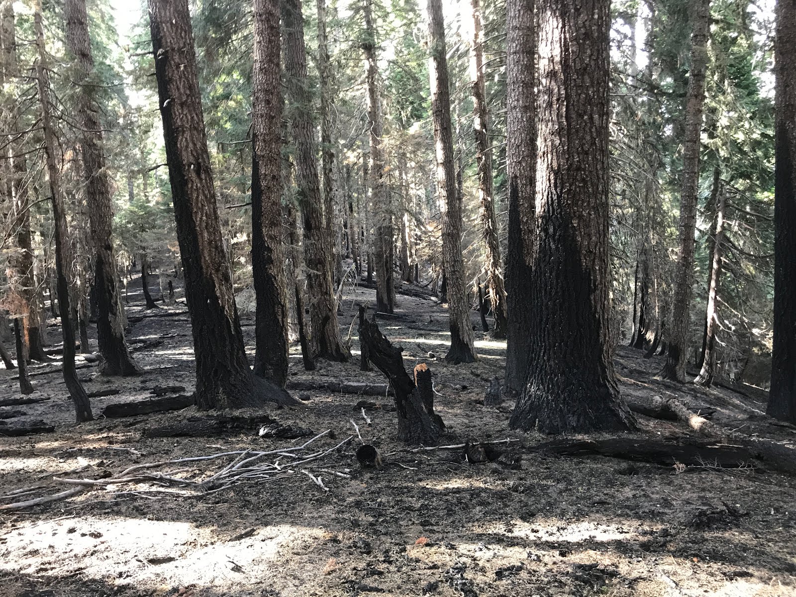
To the north, hot fire burned above Hamilton Camp, torching the true fir forest at the edge of the wet meadows. The fire cooled at the saddle and left a mosaic of burned forest and green, living trees. Heading northeast along the long granitic ridgeline between Hamilton Camp and English Peak you enter slopes that had heavily burned in 2006 Uncles Fire and re-burned in the Wallow Fire. The Wallow Fire rushed through this section with a vengeance, turning the snags black with charcoal, consuming the understory fuels and leaving a powdery layer of ash across the surface of the soil.
The ridge between Hamilton Camp and English Peak has transitioned to complex, early-seral vegetation.

Before the Wallow Fire the area supported extensive snag forests, chaparral, young conifer regeneration and dry bunchgrass and buckwheat clearings. The Wallow Fire uniformly scorched the majority of the ridge, leaving only occasional islands of young conifer regeneration, a few stands of more mature trees, and unburned bunchgrass clearings. The south-facing slopes are now blackened and will transform into yet another unique ecosystem. 

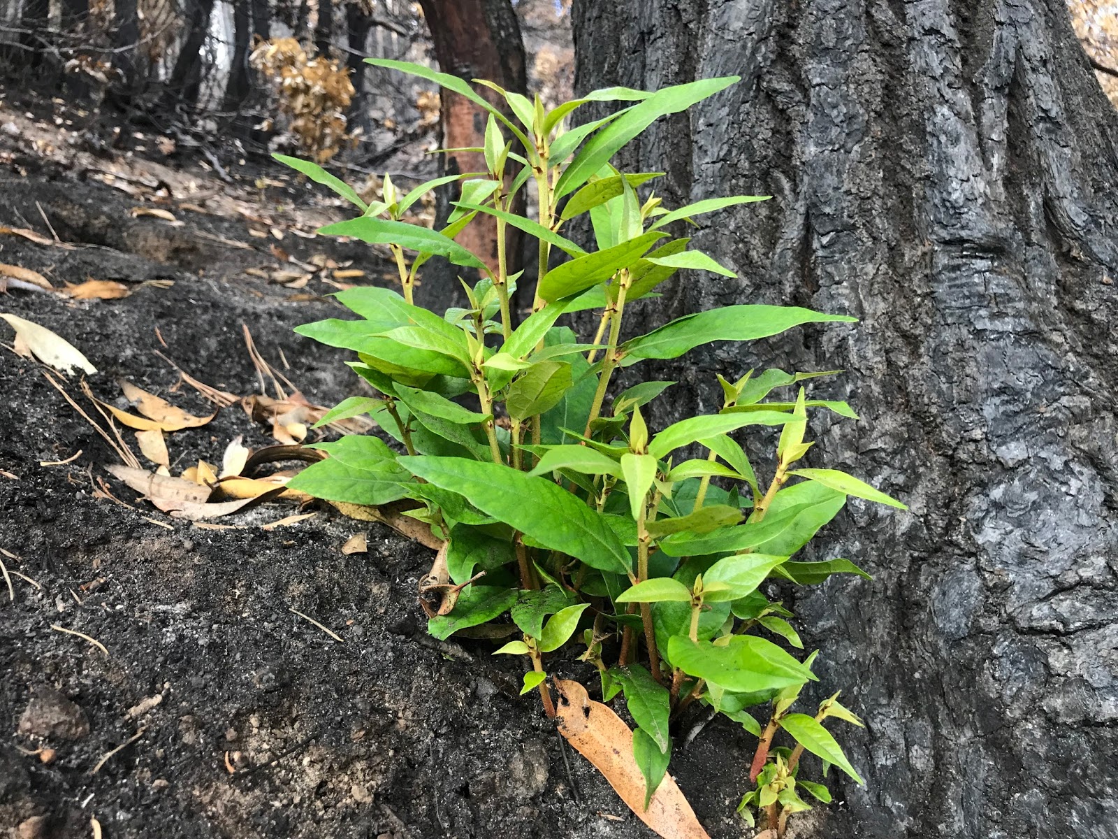
In some places snowbrush, huckleberry oak and other shrubs are  already regenerating, in other places fields of bracken fern, fireweed and dry grassy clearings are already returning. Large sections of regenerating forest were burned clean by the Wallow Fire, resetting the ecological clock.


An early-seral bunchgrass opening regenerating from the 2006 Uncles Fire.
The views are spectacular, stark, and humbling. They are also intriguing. How will the ecosystem respond? What will regenerate in this large, blackened area? How will the reburn affect stand development and species composition.

 In time, the biodiversity of the burn will become more apparent and the rejuvenation will surprise us with its abundance and beauty. From ashes, this habitat will rise, changed, but connected to its past and thriving in its own way. 

I can now envision the buckwheat fields, rock gardens, fireweed patches, dry bunchgrass clearings, vibrant green conifer regeneration, and yes, the brushfields that will grow from the blackened snags and downed wood, creating habitat and life. Pollinators, songbirds, butterflies, woodpeckers, elk, bear and wildlife of all sorts will visit these clearings for sustenance. What some might see as disaster is a new opportunity for many species in the complex, diversified conifer forests of the Klamath-Siskiyou. 

The large, high-severity burn patch extends from near Hamilton Camp to Snowslide Gulch and up to the flank of English Peak where meadow and forest alike are unburned. Rustic Tom Taylor Cabin burned to the ground in the firestorm, but English Peak Lookout, perched high in the rocks, remained safe from the flames.

On the other side of the ridge, the fire behaved very differently.  Despite the large run up Little North Fork, the North Fork of the Salmon River burned at low to moderate intensity. The Wallow Fire burned streaks in the forest and brush at the North Fork's headwaters, often dying out in the rocky cliffs, ledges and steep granite ramps above. Much of the area was either unburned or underburned, leaving the canopy intact and the mosaic only gently touched by visible fire effects.
A view from the ridge near English Peak into the beautiful English Lake Basin. The fire burned at low to moderate intensity in the North Fork of the Salmon River. The steep, granitic headwall acted as fire refugia, providing the southern-most Pacific silver fir an unburned island high in the rock.

Out the ridge, towards Diamond Lake, and the out towards Hancock Lake, lies the southern-most stand of Pacific silver fir. Pacific silver fir grows in cool, moist and often very snowy habitats. They are found in only two locations in the Klamath Mountains, one here, near Hancock Lake and another near Copper Butte and Black Mountain on the Siskiyou Crest.


Pacific silver fir near Diamond Lake.
Although the species is very sensitive to fire, it also grows in highly effective fire refugia. The southern-most population exists within a cool, moist island of forest surrounded by rocky cliffs and ledges. The hemlock, red fir and Pacific silver fir grow in dense, mature groves embedded within rock outcrops and wet meadows. Numerous recent fires have burned to the edge of this stand, but have yet to penetrate the rocky kingdom in which this population exists. The Wallow Fire burned all the way around the population, demonstrating the effectiveness of the fire refugia in which the Pacific silver fir live.

Pacific silver fir and many of our other fire sensitive species such as Alaska yellow cedar, subalpine fir and Brewer's spruce have developed an avoidance strategy, clinging to the very habitats fire cannot penetrate. They do not develop thick, insulating bark or high, fire resilient canopies; they do not thrive in the face of fire like knobcone pine, lodgepole pine or chaparral, instead they avoid fire by exploiting cool, moist and rocky, high mountain habitats. I often judge the effects of a fire on how well the fire sensitive species persist in the post-fire environment. In the case of the Wallow Fire, I have seen significant viable populations of subalpine fir, Brewer's spruce and Pacific silver fir avoiding the flames in their rugged mountain haunts. Clinging to the rocky, north-facing slopes where fire struggles to burn, our ancient relict conifer species seem to be doing just fine. 
Hancock Lake

Thursday, October 19, 2017

Burnt Peak Fire: Mixed-Severity Fire in the Applegate Foothills

The Burnt Peak Fire backed down the slopes of the Collings-Kinney Roadless Area into the Upper Applegate Valley.
I recently hiked the Burnt Peak Fire in the foothills of the Applegate Valley. The fire burned mostly within the Collings-Kinney Roadless Area in a rugged knot of mountains colonized by dense conifer forest, chaparral, live oak woodlands and deciduous oak habitats. The fire burned to the banks of Kinney and Palmer Creeks in the Upper Applegate Valley.

The Burnt Peak Fire started on August 14, 2017 high on the slopes of Burnt Peak, a summit of scrub brush and forest dividing Carberry Creek from the Upper Applegate Valley. Despite burning in the heat of summer and through heavy fuel, the fire backed down the slopes of Kinney and Palmer Creek, at mixed severity. Heavy smoke inversions and moderate weather conditions kept the fire cool in most of the fire area. The majority of the fire burned in the understory of mixed conifer forest dominated by Douglas fir, ponderosa pine, madrone and live oak. 
An understory burn in the Kinney Creek canyon.
In the Kinney and Palmer Creek canyons the fire burned at low severity beneath large, old fir and maple. It crept to the banks of the streams burning undergrowth. Snags and trees undermined by fire crashed to the forest floor and crossed the streams, stabilizing stream banks, holding moisture and creating pools in these small, fish-bearing streams. The Burnt Peak fire deposited a significant amount of large woody debris in the streams, showing that fires can help create better fish habitat.

The south-facing slope above Kinney Creek after the fire.
Higher on the slopes the fire was mixed, burning some locations at high, low and moderate severity. On the most exposed and rocky slopes stands of stump-sprouting live oak grow among thickets of knobcone pine and greenleaf manzanita. These stands are the remnants of hot, stand-replacing fires that burned between 1854 and 1917. They are fire dependent plant communities requiring periodic stand-replacing fire to persist and regenerate.

Still higher on the southern face of Burnt Peak, dense thickets of post oak, live oak, birchleaf mountain mahogany and silk tassel grow adjacent to small grassy clearings filled with rabbitbrush and laced in tufts of jagged bedrock. The dense brushy thickets burned off, while the fireline built by fire suppression crews stopped the fire just short of the small grassy clearings.
A view from near the summit of Burnt Peak looking across the Burnt Peak Fire in the foreground to the still burning Abney Fire in the background.

In the distance, the Abney Fire still burned on the northern face of the Siskiyou Crest, just below the Pacific Crest Trail, pouring smoke into the valley below. This summer the forests of the Applegate, from the foothills to the spine of the Siskiyou Crest burned, leaving a legacy of soot, snags, and fire-adapted forest habitats. 

After a long summer of smoke filled skies, we have received the blessing of natural, characteristic fire. Our forests have been fertilized with rich mineral ash and armored with nature's fuel reduction. Our wildlife will feast on the new grass and fresh woody shoots sprouting from burned off hardwoods and chaparral. Hollows burned in large, old-growth trees will become protection for the winter's slumbering bears or natal dens for the Pacific fisher. Fire-scorched snags will both feed and house generations of woodpeckers and songbirds. Rich fields of flowering plants will carpet the now black, burned soil, providing better habitat for many pollinators such as hummingbirds, butterflies and native bees next spring.

Fire is a natural process, as much a part of the Applegate Valley as the acorns on the oak trees, the salmon in our streams and the towering pine trees. The return of fire brings renewal and life to a landscape intentionally starved of fires for decades. The rejuvenation has already begun, transforming the white ash into green, verdant re-growth. 

Low-severity fire in Kinney Creek.

The Burnt Peak Fire allowed the long-suppressed natural process of fire to once again create a multitude of ecological benefits. The forests of the Siskiyou Mountains are well adapted to wildfire and the effects of the Burnt Peak Fire were both characteristic and beneficial. 

The Burnt Peak Fire demonstrates that many forests, just like those on Kinney and Palmer Creek can sustain healthy, mixed-severity fire, despite decades of fire suppression. The current rhetoric of catastrophic fire is a false narrative based more on fear than reality. When you actually walk and explore contemporary wildfires in the Klamath-Siskiyou Mountains you will find more renewal than destruction and more life than death. These fires are not destroying our forests, they are making them wild and whole again.
Forests just like this can be found all across the Applegate watershed and are often targeted for commercial thinning by federal land management agencies. We are told that the stand density, fuel loading and species composition makes these stands highly susceptible to uncharacteristic fire effects. We are also told that we must chose to either log these forests, or lose them to high-severity fire. Yet each summer thousands of acres, just like this, burn at low-severity all across our region. 

Sunday, October 1, 2017

2017 Creedence Fire: The Smoke has cleared on Grayback Mountain

A view into the headwaters of O'Brien Creek from Grayback Mountain. Both sides of O'Brien Creek Meadows and the forested ridge to the right underburned in the Creedence Fire, leaving a rich, green forest canopy.
The Creedence Fire began with a strike of lightning on August 14, 2017 and burned in the back-country surrounding Grayback Mountain and the Kangaroo Roadless Area. Two fires were ignited, one on the lower slope of Bigelow Creek, and another high on the ridge near O'Brien Creek Meadows in the Grayback Mountain Botanical Area, at the headwaters of Carberry Creek. The two fires later merged to become the Creedence Fire, the westernmost fire in the Miller Complex.

Grayback Mountain is one of the Applegate Valley's most iconic and well-loved landscapes, rising to 7,048' above Thompson Creek, Carberry Creek and the Williams Valley. The forests, meadows, and wilderness-quality landscapes surrounding Grayback Mountain are cherished by hikers, wildflower enthusiasts, and various outdoor recreationists for their beauty and ecological integrity. Grayback Mountain is also a major watershed divide between the Applegate River and Illinois River watersheds. 

A beautiful underburn in white fir forest on the southwest flank of Grayback Mountain, in the Kangaroo Roadless Area.

The Creedence Fire burned 2,093 acres on both sides of the divide, including portions of O'Brien Creek and the Sturgis Fork of Carberry Creek, as well as Little Creek, a tributary of the Illinois River.  

Fire severity in the Creedence Fire was extremely minimal, with the vast majority of the fire burning at low severity. Forests of varying ages, compositions, stand densities, fuel profiles and structural conditions burned at low severity. Nearly all the old, fire-resistant forest in the Creedence Fire burned in the understory, clearing fuel and maintaining canopy conditions. Where high-severity fire did occur, it did so in ecosystems where high-severity fire is both healthy and beneficial, such as montane chaparral, knobcone pine and fire-mediated hardwood stands. These plant communities are dependent on high-severity fire and do not build natural fire resistance. Instead, these habitats are resilient to high-severity fire and respond with increased vigor and significant regeneration.

Fire severity in the Creedence Fire was heavily influenced by atmospheric inversions, favorable local weather patterns and slope aspect, with south-facing slopes sustaining higher fire severity. Pre-fire vegetation patterns also played a role in shaping the mosaic, but fuel loading and stand density had little influence on fire effects.
Species such as knobcone pine depend on stand-replacing fire for regeneration. Periodic high-severity fire promotes vigor, regeneration and renewal in the montane chaparral and knobcone pine plant community.
Recently, the Forest Service lifted a few of its fire related road closures, allowing access to much of Sturgis Creek. Currently, O'Brien Creek Road and the O'Brien Creek Trail are not open for public use and the Grayback Mountain Trail on adjacent BLM land is also temporarily closed. Although the roads and trails are closed, the area is open to rugged, cross-country hiking. A few mornings ago I drove up Sturgis Creek to check things out. 

I parked at the southeast corner of the fire near the banks of Sturgis Creek at about 3,200'. I started up the steep, south-facing slope, first in plantation forest, then into the Kangaroo Roadless Area. 

Dense stands of chinquapin, madrone and live oak grew from rocky slopes along with widely scattered old-growth fir. The massive old fir grow as isolated individuals among the vast groves of hardwood trees. The fire in this portion is mixed, but the large old conifers have mostly survived.

Green leaf manzanita burls.
As I climbed onto increasingly steep, dry, rocky and exposed slopes, the character of the fire changed. The fire ran through the greenleaf manzanita, young live oak, chinquapin, massive, wide-branching knobcone pine, and scattered populations of maturing ponderosa pine and Douglas fir at high severity. 

Although small patches of forest remain, the southwest-facing slope has mostly burned off, leaving the charred root burls of stump-sprouting greenleaf manzanita (Arctostaphlyos patula) and the ghostly, scorched-off snags of conifer trees. The odd looking manzanita burls store abundant energy in their bulging root crowns, and the energy is utilized following high-severity fire. The shrubs will sprout back from the charred, black burls. Although not dominant within the stand, a significant population of relatively old knobcone pine burned in the fire, leaving distinctive snags, their branches lined in fire-opened seed cones. 

Chinquapin resprouting weeks after the fire.
To some, the effects of the high-severity portion of the Creedence Fire may appear catastrophic, but for this ecosystem fire represents renewal. The manzanita, live oak and chinquapin will resprout; in fact, the chinquapin has already burst back to life with the fresh green shoots of a new tree, no more than a few weeks after the fire swept through this stand. Knobcone pine is a serotinous species, meaning the heat of fire, especially stand-replacing fire is required to open the resin-sealed pine cone, releasing the seeds and triggering germination. High-severity fire is required for regeneration and renewal in the montane chaparral and knobcone pine plant community that dominates the slope. The Creedence Fire blackened the slope in this particular spot, and in doing so will reinvigorate this specific habitat type, maintaining biodiversity on the landscape. 
The big forested ridge in the foreground underburned in the Creedence Fire. To the untrained eye one would hardly notice. The vast underburn provided fuel reduction, recycled nutrition and restored the natural fire process to these long unburned, old-growth forests in the Kangaroo Roadless Area.

When I reached the ridgeline above the fire seems to have slowed, burning in a mosaic pattern. The fire thinned the Douglas fir, white fir and ponderosa pine groves, clearing understory fuels and recycling nutrition. The vast majority of the stand's largest trees, including ponderosa pine up to 6' in diameter, survived the fire. The north slope dropping into O'Brien Creek burned at low severity, beneath massive, old fir trees. Climbing the ridge, the underburn continued through a variety of stand types dominated by white fir. 

Still climbing upward, I finally broke out of the forest and into open manzanita fields, speckled in symmetrical young fir, some bronze and scorched, while others remain green, vibrant and unscathed. Broad views extend to the south and east. The Abney Fire billowed in the distance, pouring smoke across the jumbled ridges and rugged canyons of the Siskiyou Mountains. 
The green forests and wet meadows in upper O'Brien Creek burned only at the margins. A few stringers of trees were burned in the rocky outcrops, and patches of brush burned in the rocks. For the most part very little has changed on Grayback Mountain.

The rocky ledges offer protection to fire sensitive mountain hemlock then drop into the headwaters of O'Brien Creek, a lush green band of meadow below the rocky summit of Grayback Mountain. Although the fire burned on either side of the meadows, the wet meadow habitat created a barrier for the Creedence Fire and moderated fire severity even further.

As I climbed the ridge towards the summit of Grayback Mountain, the fire burned in a patchy mosaic, torching off patches of manzanita and groupings of windswept fir. The fire burned around, but did not consume the small, disjunct population of bitterbrush (Purshia tridentata) about halfway to the summit. The small, sparse bench of crushed granite provided a fuel brake, protecting the bitterbrush.

As I climbed towards the summit a misty rain fell and clouds swirled around the surrounding canyons. After a few hours of hard hiking and nearly 4,000' vertical feet, I reached the jumbled mound of white granite boulders at the mountain's 7,048' summit and suddenly the sky cleared. 
A view southeast across the Kangaroo Roadless Area and the Creedence Fire from just below the summit of Grayback Mountain.

I looked out across the Siskiyou Mountains and thought of the political firestorm still raging as the wildfires of 2017 smolder and burn themselves out. I thought of how these natural, unavoidable events are exploited and manipulated to create fear, that in turn feeds political and economic interests. Wildfire, is just that, wild and largely uncontrollable. It exists outside the realm of politics and has no concern for the controversy it creates. It is a natural phenomenon existing in an largely unnatural world. 

Despite the claims of catastrophic fire and devastation, the mountains remain cloaked in a rich green veil of forest, albeit streaked and spotted in the reddish hues of fire-scorched trees. These are fire dependent, fire-adapted systems whose health and vibrancy is intimately tied to a random streak of lightning, an electrical pulse of energy, heat, and finally flame. The diversified forests of the Siskiyou Mountains were born in fire and have been shaped by its influence for millennia. 

The heavily forested ridge in the foreground drains into Little Creek, a roadless tributary of Grayback Creek. The ridgeline and the drainage below burned in the Creedence Fire as a vast, low-intensity underburn.
Now that the smoke has cleared and the fall rains have moistened the dry summer air and sun-baked fuels, we can see through the haze and past the fear. When I looked out across the mountains I felt no regret or sorrow for what was lost, instead I saw a familiar, decidedly functional landscape, undergoing transformation and change. 

In the Applegate watershed, much was gained. Fire was restored to over 37,000 acres, and in some of the most intact habitats in our region. It is my hope that through these fires our forests have become more diverse and fire-adapted. It is also my hope that our human communities can adapt and evolve to embrace this raw elemental force and celebrate the beauty of fire's influence. We must learn to live with fire. It is a vital natural process, with the power to shape our landscape and the ability to capture our minds.

Fire can be destructive in a sense, but like nature's phoenix, it brings renewal. May that renewal continue, both on the landscape and in our collective minds. Fire is a part of life in the Siskiyou Mountains, it is as natural as the wind and rain. As a society we must find ways to embrace and appreciate the role fire plays. 
From the Creedence Fire looking south across Sturgis Creek to Steve Peak. Let us celebrate the beauty of nature's phoenix.