Tuesday, November 5, 2013
Monday, October 21, 2013
Hinkle Lake Revisited: The Beginning of Recovery
| The Hinkle Lake Basin with Whisky Peak in the background |
October, 2006 OHV tracks in lake
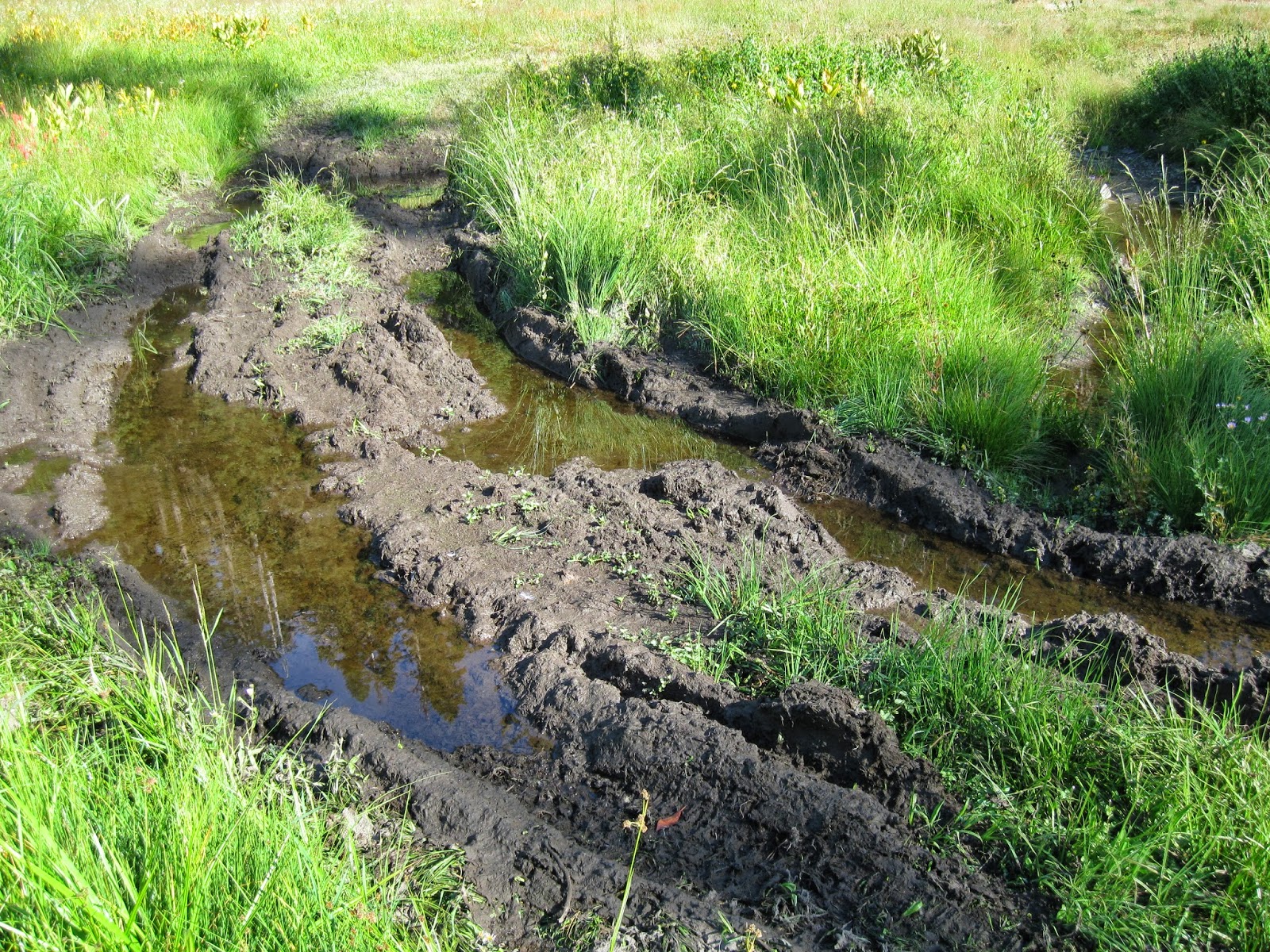
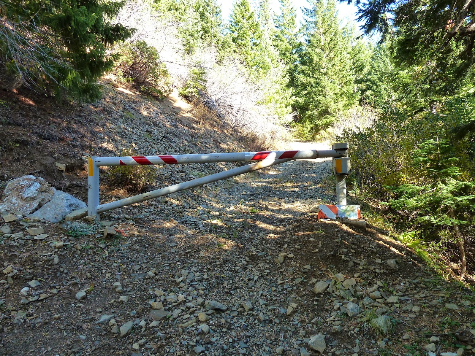
For years, the meadows and lake basin were abused by unmanaged and illegal OHV use. The wetlands around Hinkle Lake and Kendall Cabin had become mud bogs, and vehicle tracks could be found throughout the broad subalpine meadows and flower fields. I am happy to report that some of these areas have begun to heal and re-vegetate. Although the impacts to hydrology and riparian function may be more long term, this year they were not made worse with each trespassing vehicle. The last time OHVs were seen in the Hinkle Lake Basin was in June, 2013. It does not appear as if any further trespass has occurred. When I arrived there this past weekend I was heartened to see the gate locked and other hikers on the trail!
Summer 2012 Fall 2013
As these before and after photos show, there are visible signs of recovery within the meadows and lake margins. We have begun to make a difference, yet the struggle is not over. We still need to advocate for official designation of road #850 as the "Hinkle Lake Trail," and for inclusion of the Hinkle Lake Basin in the Red Buttes Wilderness in order to keep it protected in perpetuity. The Hinkle Lake Basin is a wilderness caliber landscape and should be treated as such.
| Locked gate on road #850, aka "The Hinkle Lake Trail" |
Please contact the following Forest Service officials and tell them you support the measures they have taken to protect the Hinkle Lake Botanical Area and encourage them continue these actions into the future.
| Adequate signage is helping inform the public of the closure |
Donna Mickley, District Ranger, Siskiyou Mountains Ranger District: dmickley@fs.fed.us
Rob MacWhorter, Forest Supervisor, RR-SNF: rmacwhorter@fs.fed.us
Thursday, October 17, 2013
Grazing issues on the Siskiyou Crest
| Alex Hole, in the Condrey Mountain Roadless Area, is being heavily impacted by unmanaged cattle. |
I recently went to the eastern Siskiyou Crest with Felice Pace from the Campaign to Reform Public Land Grazing in Northern California. Felice has been monitoring grazing allotments in the Marble Mountains Wilderness Area for numerous years and is working to reform grazing practices that are violating the Clean Water Act and degrading some of the region's most pristine high mountain springs, wetlands, and meadows.
In early September we set out across the Siskiyou Crest monitoring grazing allotments on both the Rogue River-Siskiyou National Forest and the Klamath National Forest. What we found was appalling, yet all too routine in the mountains of the west. Cattle have been overgrazing the high mountain meadows of the Siskiyou Crest for decades. Beginning over 150 years ago sheep, then cattle began overgrazing green fescue and other upland grasses in dry clearings, meadows, and grasslands. These historic impacts have reduced many dry upland meadows and grasslands to sparse and dusty clearings nearly devoid of vegetation. The productivity of these sites have been so thoroughly trampled,compacted, and overgrazed that to this day little remains of the original plant community. This is especially evident in the schist soils near Condrey Mountain.
| The sparse schist clearing in the foreground once supported a more rich and diverse herbaceous plant community but has been degraded due to historic and contemporary livestock grazing. |
Current management, stocking levels and continuous summer grazing is clearly not allowing these areas to recover. The lack of available forage in upland sites is also forcing cattle to graze more extensively in wet meadow areas as very little forage currently exists outside this habitat. The trampling of springs and wetlands, the fragmentation of willow stands, and the deposition of fecal matter directly into high mountain streams has taken a heavy toll and the impacts continue to this day.
We found the most extensive damage in Alex Hole, a broad glacial bowel at the headwaters of Elliott Creek, at the eastern margin of the Condrey Mountain Roadless Area. The area is within the Elliott Grazing Allotment and was proposed in the 1990s as a designated Botanical Area by the Rogue River National Forest. It was excluded from this designation based on the following statement from the 1995 Draft Land and Resource Management Plan (LRMP): "The wet meadows are in a particularly disturbed condition. Exclusion of cattle may be a prerequisite for returning the plant communities to their former condition and the establishment of a botanical area."
Indeed, damage to wet meadows, seeps, springs, high mountains streams, and willow wetlands in the area is significant and troubling. The area is currently overgrazed and over-utilized, meaning essentially all available forage has been consumed by grazing cattle and native ungulates. The lack of forage throughout the allotment is forcing cattle to congregate in wetlands and springs. Nearly all water sources and springs have been trampled, including deep hoof prints that extend over 6" into the soft wetland soil. Stream banks are heavily disturbed, willow wetlands badly fragmented and browsed, and fecal matter litters the streams and springs. The area is being severely damaged by unmanaged cattle and inadequate herding. Cattle dispersal techniques are not being utilized and no attempt to protect these otherwise pristine water sources is being made by either the permittee or the Forest Service.
| Heavily trampled springs in the Alex Hole area. |
Other areas of extensive damage include Mud Spring, a particularly wet and sensitive meadow near Condrey Mountain and Silver Fork Basin in the Beaver/Silver Grazing Allotment beneath Dutchman's Peak and Observation Peak. The Silver Fork Basin has long been one of the most overgrazed meadow systems on the Siskiyou Crest. Extensive damage was done at the turn of the century and massive "range improvement projects" were conducted in the 1950s, trying desperately to grow some grass. The ridge at the head of the meadow system was so badly overgrazed and subject to such heavy erosion that the Forest Service terraced the slopes to stabilize the gullies which were forming. Watering systems were put in place and non-native grasses were seeded. Yet rather than provide the region with a much needed rest, cattle remained in the basin, eating forage as fast as it could grow. Today conditions are somewhat better but stocking levels are compounding the impacts of the past and disrupting recovery in this dramatic meadow basin.
| Extensive moist meadow damage and loss of vegetative cover in Silver Fork Basin |
The impacts at Mud Spring are inflicted by a combination of grazing and inappropriate OHV use. The wetland is badly trampled and riddled with OHV tracks. A small spur road leading to the springs should be closed to vehicle use to reduce impacts to hydrology, vegetation, and water quality.
| Heavy trampling and OHV use at Mud Spring. |
On the Klamath National Forest side of the ridge we also found extensive damage to wetlands, seeps, and springs in upper Jaynes Canyon, Cow Creek Glade, Buckhorn Springs and Reeves Ranch Spring. Reeves Ranch Spring has had protective fencing and water developments projects completed in the past, seeking to reduce or eliminate grazing impacts to springs, however, these have been neglected and made entirely dysfunctional through a lack of maintenance. Public funds utilized to build this protective fencing and develop water sources away from sensitive springs have been wasted and the infrastructure is in disrepair.
Due to significant overgrazing, over-utilization, impacts to water quality, and low production across the range this season, we have asked that the cattle be removed immediately. This will allow some recovery and re-growth in native meadow communities while also allowing the streams to heal some before next grazing season. Long-term some of these areas may need an extended period of rest to allow for adequate riparian function and the maintenance of native plant communities. Please contact the responsible Forest Service officials and ask that they consider providing some of the most damaged areas this extended period of rest. In other areas a reduction in stocking levels, increased herding and management as well as efforts to protect waterways, springs, and wetlands are needed.
Please contact the following agency officials
Donna Mickley, District Ranger, Siskiyou Mountains Ranger District: dmickley@fs.fed.us
Rob MacWhorter, Forest Supervisor, RR-SNF: rmacwhorter@fs.fed.us
Sunday, September 8, 2013
Maps for The Siskiyou Crest: Hikes, History & Ecology
![]() |
| Applegate Foothills North |
This map includes the Buncom, Dakubetede, and Wellington Butte Roadless Areas.
![]() | ||
| Applegate Foothills South |
This map includes the Boaz Mountain, Collings/Kinney, Little Grayback, Elliott Ridge, Stricklin Butte, and Whisky Peak Roadless Areas.
![]() |
| Red Buttes Region |
This map includes the Condrey Mountain, Indian Creek, Kangaroo, and Grayback Range Roadless Areas.
![]() |
| Siskiyou Crest Roadless Areas |
This map includes the Big Red Mountain, Glade Creek, Observation Peak, and Mudusa Flat Roadless Areas.
![]() |
| Siskiyou Wilderness Area |
This map includes the Siskiyou Wilderness Area and the adjacent roadless areas.
Friday, August 30, 2013
Radio Interview on the Jefferson Exchange
| The view from White Mountain in the Condrey Mountain Roadless Area |
Thursday, August 29, 2013
Summer on the Siskiyou Crest
| Devil's Punchbowl in the Siskiyou Wilderness |
| Jeffrey Pine (Pinus jeffreyi) on Cook n' Green Butte in the Kangaroo Roadless Area |
| 8' DBH Western White Pine (Pinus monticola) at Steve Fork in the Red Buttes Wilderness |
| Beargrass (Xerophyllum tenax) in the Siskiyou Fire in the Siskiyou Wilderness |
| Serpentine ridge in the Red Buttes Wilderness |
| The Silver Fork of Elliott Creek from the Pacific Crest Trail |
| Echo Lake in the Red Buttes Wilderness |
| Incense-cedar (Calocedrus decurrens) on Studhorse Creek in the Condrey Mtn. Roadless Area |
Saturday, August 17, 2013
Protect the Hinkle Lake Botanical Area
| The Hinkle Lake Botanical Area hosts some of the Siskiyou Crest's most spectacular high mountain meadows. |
Hinkle Lake and the Hinkle Lake Botanical Area are located in the Oregon section of the Kangaroo Roadless Area, adjacent to the Red Buttes Wilderness, above Carberry Creek in the Upper Applegate River drainage. The Hinkle Lake Botanical Area is a place of spectacular beauty,set aside for its significant botanical diversity and quality of habitat. The meadow system surrounding Hinkle Lake is one of the largest in the Red Buttes region, and it hosts numerous rare and endemic species. One particularly rare species, known as the Alpine Liverwort (Chilosyphus gemmiparus), is found in only six other locations worldwide. Unfortunately, in the Hinkle Lake Botanical Area, Alpine Liverwort habitat is being severely degraded by illegal Off Highway Vehicle (OHV) use.
Thirty-three years ago the Forest Service recognized the negative impacts that motor vehicles were having on the meadows around Hinkle Lake. Since June of 1980 a Forest Order Closure (RSF #106) has been instituted in the Low Gap/Hinkle Lake area. This officially closed the area to motorized use due to both resource damage and public safety concerns after a young man was killed on his OHV in the basin. Forest Service Road 850 was closed by a locked gate and the section of road entering the basin was officially dropped from the Forest Transportation System, as well as from Forest Service maps, making all motorized use illegal. At an undisclosed date the gate was vandalized and vehicle trespass into the area became routine.
| OHV damage at the shoreline of Hinkle Lake |
Ten years later the area was designated as a Botanical Area under the 1990 Land and Resource Management Plan. This designation prohibits OHV use off of National Forest System roads. Botanical Area designation also emphasizes management and public use that is compatible with botanical preservation. Despite clear management directives and attempts to eliminate OHV travel in the area, the problem has continued and intensified. Botanical Area Management Plans mandated in 1990 were never produced by the Forest Service, thus the impacts to this Botanical Area went unmonitored and undocumented, and the Forest Order Closure was routinely violated by all classes of motor vehicles. Severe impacts to wetlands and high mountain meadows have occurred in violation of the Aquatic Conservation Strategy (ACS) objectives and in contradiction to Botanical Area management protocol. Furthermore, the area was identified in the Carberry Creek Watershed Analysis as an area of concern in regard to “resource damage,” and further identified the “Hinkle Lake meadows and road system” as a priority for restoration.
Despite the agency's clear land management mandates, the issue of OHV use in the area went unaddressed for over 30 years. Recently, however, a coalition of environmental groups, hiking clubs, and concerned citizens have pushed the Forest Service to enforce this longstanding motor vehicle closure. A more proactive approach by both the public and the agency has begun to turn the tide, yet more needs to be done.
| OHV damage of wet meadows in the Hinkle Lake Botanical Area |
The solution to this ongoing problem
is to address the physical trespass of motor vehicles, inadequate agency monitoring and enforcement, as well as the inappropriate and illegal OHV use which has caused resource damage in the area. These problems can all be
addressed by implementing the following proposal:
1) Make road 850 physically
impassable to all classes of motorized vehicles through the use of tank traps,
earthen berms, gates, and other appropriate structures
2) Officially declare road 850 a Siskiyou Mountain Ranger District hiking
trail open only to non-motorized use
3) Adequately sign the new Hinkle Lake Trail, possibly with a message board explaining the motor vehicle closure
The trail proposal would not trigger the National Environmental Policy Act (NEPA) as no ground disturbing activities would be necessary and the closed road bed would simply become a footpath. No physical trail clearing or development would be needed. The large and developed Fir Glade Trailhead already exists at the intersection of road 800 and closed road 850, which could easily be used for the new Hinkle Lake Trail as well. A new trail sign may be the only new infrastructure needed. The agency would not need to allocate significant funding and a scoping period providing public comment has already been completed.
By encouraging an appropriate and compatible use in the area other more inappropriate uses would be reduced. The public could help to monitor the closure, a task the agency does not seem capable of due to budget and staffing constraints. It also seems clear that the current illegal OHV use in the area would be excluded as other uses, such as hiking, take hold. Simply put OHV users would not feel comfortable trespassing in the area and breaching the closure if other users were present to observe the violation. If vandalism and OHV abuse were to occur, other forest users (e.g. hikers) could notify the agency of such abuse. To implement this proposal I believe the agency would simply have to say it was so and find minimal funding to create the physical structures needed to eliminate OHV use and access. The closure is already in place, the area is an inventoried roadless area, designated as a Botanical Area, and already the focus of closure efforts.
Please contact the Forest Service and encourage them to consider this proposal and to work with local partners (e.g. non-profits, advocacy groups, hiking clubs, concerned citizens, the Native Plant Society of Oregon etc.), to manage the Hinkle Lake basin in a manner that is consistent with current laws, land management directives and designations. Please let them know that Hinkle Lake is a high mountain jewel, to be protected, restored, and preserved for future generations.
Contact the following Forest Service officials:
Please contact the Forest Service and encourage them to consider this proposal and to work with local partners (e.g. non-profits, advocacy groups, hiking clubs, concerned citizens, the Native Plant Society of Oregon etc.), to manage the Hinkle Lake basin in a manner that is consistent with current laws, land management directives and designations. Please let them know that Hinkle Lake is a high mountain jewel, to be protected, restored, and preserved for future generations.
Contact the following Forest Service officials:
Siskiyou Mountains Ranger District, Donna Mickley, District Ranger: dmickley@fs.fed.us
Rogue River-Siskiyou National Forest, Rob MacWhorter, Forest Supervisor: rmacwhorter@fs.fed.us
Subscribe to:
Posts (Atom)