 |
| A view across the Natchez Fire from Lookout Mountain in the Siskiyou Wilderness. |
With over 100 fires spread throughout the Rogue River-Siskiyou National Forest in mid-July, the Natchez Fire was not a high priority, and being understaffed, it continued to grow in remote and rugged terrain. The sheer number of fires and the proximity of many wildfires to nearby communities overwhelmed fire suppression crews, forcing them to prioritize.
Fires like the Natchez Fire, burning far from residential properties or communities, dropped to the bottom of the priority list. This meant that although attempts were made to suppress the Natchez Fire, crews could not successfully minimize the acres burned with an initial attack strategy. The necessary resources were not available and the terrain was simply too dangerous and extreme. Instead, crews pulled back, creating indirect firelines along existing forest roads and on the ridgeline between Little Greyback and Poker Flat, a large meadow system and designated Botanical Area adjacent to the Siskiyou Wilderness Area.
 |
| The Natchez Fire burned at mostly low severity in the forests around Poker Flat at the edge of the Siskiyou Wilderness, but did not burn directly into the meadow system itself. |
By July 23, the fire was over 2,000 acres and had spotted over existing firelines, becoming established in the headwaters of Indian Creek, high above the Klamath River and Happy Camp, California. On the evening of July 25, the Natchez Fire made a significant uphill run, again spotting over containment lines near Poker Flat. Crews began to scramble, working to keep the fire from burning into the rugged Siskiyou Wilderness Area to the south.
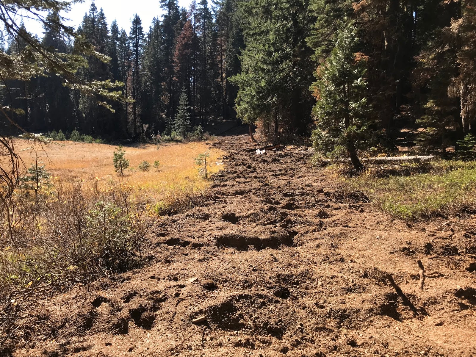
In response, crews began to bulldoze into the Siskiyou Wilderness on the Poker Flat Trail and on the spine of the Siskiyou Crest. Crews bulldozed at least two miles on the Poker Flat Trail, turning the former wilderness trail, on a long-abandoned mine track, into a dusty, disturbed dozerline. They bulldozed through headwater streams, old-growth forests, serpentine outcrops, high mountain meadows, and beautiful Jeffery pine savanna. Crews also felled large, old trees and snags along the dozerline, creating additional impacts to the region's spectacular wilderness qualities.
In addition to the bulldozing of the trail and old mine tracks, new dozerline was scrapped across the Siskiyou Crest above the Poker Flat Trail. This egregious bulldozing of an intact wilderness ridgeline will have long-lasting ecological impacts.
 |
| This small meadow in the Siskiyou Wilderness on the Poker Flat Trail was bulldozed by fire suppression crews. |
Fire crews also opened old mining tracks that extend deep inside the Siskiyou Wilderness Area in order to facilitate driving into Twin Valley and a freshly constructed helipad on the ridges above Kelly Lake. The long-term damage to native plant communities, clear flowing streams and wilderness values was significant, and to make matters worse, these wilderness dozerlines did not contribute towards the fire's ultimate containment.
On July 27, when the fire activity increased, spot fires became established south of the dozerlines into both the South Fork of Indian Creek and Twin Valley Creek, making the wilderness dozerlines completely obsolete. At this point, crews were left with little option but to abandon the dozerlines punched into the Siskyou Wilderness.
 |
| Massive old trees up to 7' diameter were removed along the Poker Flat Trail during fire suppression. This tree was removed on the Siskiyou Wilderness boundary. Fire crews also bulldozed through the headwaters of Sutcliffe Creek's West Branch. |
At the same time, dozers began pushing into the roadless headwall of Dunn Creek, attempting to cut off the fire's western flank. The dozerline was built on extremely steep, erosive slopes and was quickly passed up by the Natchez Fire's western movement.
After doing great damage to the Siskiyou Wilderness by bulldozing open old mine tracks, creating new dozerline on ridges, felling hundreds of snags and blasting apart rock outcrops with "fireline explosives", crews finally began to implement Minimum Impact Suppression Tactics (MIST) developed to maintain wilderness values while suppressing wildland fires. MIST is mandated under the Klamath National Forest Plan in the Siskiyou Wilderness Area, but in this situation, was instead used as a last resort, when more aggressive and impactful suppression tactics failed.
In the end, crews used natural barriers to slow and contain the fire. In this case, these natural barriers were composed of a series of sharp and relatively barren granitic peaks to the west of the fire, extending from Preston Peak to the Lieutenants, Polar Bear Mountain and along with the open serpentine slopes of Lookout Mountain. Adjacent to these sharp peaks was last year's Eclipse Fire footprint, creating an impermeable firebreak to the south-southwest. Crews worked to steer the fire towards these relatively fire impermeable summits and recent fire footprints, containing the fire by corralling it into the wilderness.
 |
| The Natchez Fire burned at low- to moderate-severity at the headwaters of the South Fork Indian Creek. The large granitic summits in the background, including Preston Peak, Copper Mountain and El Captain, were used as a "natural barrier" to contain the western flank of the Natchez Fire. |
The fire was also backing moderately into the South Fork of Indian Creek in the Cole Creek drainage burning towards a few isolated rural residences. Fire crews successfully defended all threatened structures and for a short time held the fire on the South Fork of Indian Creek.
 |
| Low-severity fire in the South Fork of Indian Creek. |
Starting at the 2017 Eclipse Fire perimeter near the Baldy Mountain Lookout, suppression crews began methodically backburning into the South Fork of Indian Creek, nearly tripling the size of the fire. This created a safe, effective and relatively low-impact fireline and the tactical firing operations created beautiful low to moderate severity fire effects. It also quite effectively protected the community of Happy Camp from the Natchez Fire. The decision to initiate large-scale burnouts from the Eclipse Fire contingency line was controversial in some local communities, but should be applauded as appropriate, safe and effective fire management.
On September 25, the Natchez Fire worked its way through the rock near Cyclone Gap, burning over the natural barrier used as fireline and into the headwaters of Clear Creek. The fire burned onto Copper Mountain and Preston Peak, reaching into the Raspberry Lake basin as a mixed-severity fire. Over the course of the next few days the fire marched into Clear Creek and onto the face of Rocky Knob. This portion of the fire burned in the headwaters of Clear Creek until extinguished naturally in October.
 |
| The Natchez Fire burned as a low-severity underburn around the shores of Kelly Lake. |
In all, over 38,000 acres burned in the Natchez Fire. Although fire severity maps have not been released, it is obvious that large swaths of forest burned at low severity. The Natchez Fire was a beautiful natural event with profoundly beneficial effects. Blanketed by dense smoke inversions and blessed with very little wind, the Natchez Fire burned in a mosaic of mostly low to moderate severity, reducing fuels, maintaining old-growth canopies, invigorating plant communities, and reintroducing natural process to the diversified forests of the Siskiyou Crest.
 |
| Low-severity fire in Lower Twin Valley. |
In upper Dunn Creek and Poker Creek, the fire burned in a more mixed pattern, including low-, moderate- and high-severity fire. In places, the fire ran uphill, burning vertical swaths of forest at high severity and leaving behind blackened snag forests, filled with a cacophony of hairy and white headed woodpeckers.
 |
| The white headed woodpecker is often abundant in fire-killed forest throughout the Siskiyou Crest. Photo: Frank Lospalluto |
 |
| The Natchez Fire in Upper Twin Valley and on the face of Polar Bear Mountain above. |
 |
| The Natchez Fire burned at low severity in the forests around Brad's Lake. |
The Siskiyou Wilderness, like all wilderness, contains relatively intact biological legacies and remote, isolated landscapes that provide habitat for free-roaming wildfire. Although valuable as a human refuge, wilderness is not just a place to renew our souls, find solitude and connect with nature. Wilderness defines our landscapes, informs our sense of place and provides the natural world an opportunity to demonstrate the efficiency, artistry, and abundance it can maintain. Wilderness represents the uncontrolled spirit of nature and is one of the only places where natural process can sustain biodiversity at evolutionary time scales.
 |
| Free-roaming wildfire burning in late October in the Siskiyou Wilderness at the headwaters of Clear Creek, at the end of the Natchez Fire. |
I am glad to see it was a good fire in that area but so disappointed at the work done by humans. That tree was dropped for the fun of it and that dozer line was not needed...guess the Bigfoot Trail Alliance has some rehab trail work to do.
ReplyDeleteThanks for keeping an eye out there Luke.
This comment has been removed by a blog administrator.
ReplyDeleteCuriosity question for you. Have you ever been a Wildland firefighter? That tree might have been an issue tree. They are called snags and they pose a threat to us if they fall and we are working underneath them. If you actually read the picture description the tree could have also compromised the fire line or in this case the trail. Meaning that if that tree had fallen on its own and crossed the trail the other side of that trail that had been unburned would have burned and depending on what was on the other side of it could have killed or hurt firefighters. That dozer line could have saved trees or anything that if destroyed could be detrimental to the environment that lived there. So do me a favor go be a Wildland firefighter put your life on the line and tell us again that that tree was cut down for fun and the dozer line was pointless. Spend 14 days of your life non stop working your butt off for 18-24 hours at a time and having to make a choice of food or shower because you got to camp late while you sit at home on your nice bed or couch. Thanks.
ReplyDeleteKasvava metsa müük tähendab seda, et müüakse ainult metsamaal kasvavat täiskasvanud metsa, s.o õigust raiuda metsa. Pärast raietöid ja metsamaterjali müüki jääb metsamaa metsaomanikule.
ReplyDelete