Tuesday, May 28, 2019

The Impact of Wilderness Bulldozing in the 2018 Fire Season


A bulldozed fireline built across the PCT in the Soda Mountain Wilderness during the 2018 Klamathon Fire. As you can see the fire never reached this fireline and it played absolutely no role in fire containment.
With fire season fast approaching, federal land managers and local politicians are promoting aggressive, industrialized, backcountry fire suppression in our most intact, wilderness landscapes. Many residents in the region are concerned that the landscapes we know and love will be damaged in that process. Being generally rugged, remote and far from human communities, wilderness firefighting is often inappropriate, unnecessary, ineffective, environmentally damaging and extremely dangerous for fire crews.


Last year, fire managers in southwestern Oregon and northwestern California authorized the use of bulldozers in the Soda Mountain Wilderness east of Ashland, the Kalmiopsis Wilderness west of Cave Junction, and in the Siskiyou Wilderness between the Illinois Valley and Happy Camp, California. These authorizations for the use of bulldozers in local wilderness areas demonstrate a trend towards more damaging backcountry firefighting tactics in our region, they also account for as many authorizations as were approved throughout Oregon and Washington over the previous 12 years combined.


A mortar or grinding stone bulldozed in a Native American archeological site.
Last summer, during the Klamathon Fire, BLM and ODF fire crews bulldozed roughly 30 miles across the Soda Mountain Wilderness and Cascade-Siskiyou National Monument, bulldozing straight through streambeds, a number of rare plant populations and numerous Native American archeological sites. These dozerlines were driven extensively, providing vehicle access to the heart of the Soda Mountain Wilderness, compacting soils, creating erosion and spreading noxious weeds. Massive landings were also bulldozed on wilderness ridgelines to create helicopter pads, safety zones, medivac and hoist sites. Wilderness trails such as the Pacific Crest Trail, the Lone Pilot Trail and the Boccard’s Point Trail were bulldozed, degrading the wilderness experience for generations of backcountry enthusiasts and damaging natural habitats.


Ironically, the extensive bulldozing in the Soda Mountain Wilderness played no direct role in fire containment (an estimated 80% was contained with hand built firelines) and numerous bulldozer lines were miles from any fire activity. Yet, while crews bulldozed the wilderness, the weather was shifting, the fire was burning back on itself and had begun running out of steam. This allowed hand crews to “go direct” and build handlines, containing the Klamathon Fire with far less damaging methods than the dozerlines built crudely through the wilderness. 


Although the Klamathon Fire had tragic outcomes in the town of Hornbrook, California, where regrettably homes burned and a life was lost, the fire later burned at low to moderate severity throughout the Soda Mountain Wilderness, creating beneficial fire effects. It was largely the suppression efforts themselves that impacted ecological values, not the natural fire process.


The Klamathon Fire was largely a low severity grass fire within the Soda Mountain Wilderness and Cascade-Siskiyou National Monument. This picture was taken on Scotch Creek in the spring of 2019, less than one year after the Klamathon Fire.


Elsewhere in the region, fire crews for the Klamath National Forest bulldozed the Poker Flat Trail in the Siskiyou Wilderness and portions of the adjacent roadless area during the Natchez Fire. This dozerline was built into some of the most intact habitat on the Siskiyou Crest and again played no role in fire containment. It was built directly through headwater streams, serpentine outcrops, old-growth forests and high mountain meadows. The Natchez Fire burned in a rich and beneficial, mixed severity fire mosaic with substantial low severity fire effects, and once again, the most damaging effects can be attributed directly to suppression efforts.


Forest Service fire managers also twice authorized the use of bulldozers in the Kalmiopsis Wilderness, proposing to bulldoze a high ridge south of the Illinois River and along the Illinois River Trail to Bald Mountain and beyond to South Bend Mountain. Despite attaining authorization, these dozerlines were never created and the Kalmiopsis Wilderness was spared the raw, bulldozed wounds inflicted on portions of the Siskiyou and Soda Mountain Wilderness last summer.

 
A fireline bulldozed across a high mountain meadow in the Siskiyou Wilderness during the 2018 Natchez Fire. This particular dozerline, built within the wilderness, played no role in fire containment.

Wilderness has become an increasingly rare resource and is important in maintaining clean water, biodiversity and wildlife habitat. It is also loved by many in the region and provides an opportunity to experience wild nature and escape the pressures of daily life. According to recent research in the Journal Nature, 77% of the global land base has been altered by economic development, resource extraction and other forms of industrialized land management. In southern Oregon, we are lucky to have significant wilderness landscapes and these landscapes define our region.


Wilderness cannot be replaced or recreated, it plays a vital role in sustaining our region’s ecological values, our sense of place and our quality of life in southwestern Oregon. We would be wise to preserve the wilderness we have left and focus on protecting homes when wildfires occur. 
 
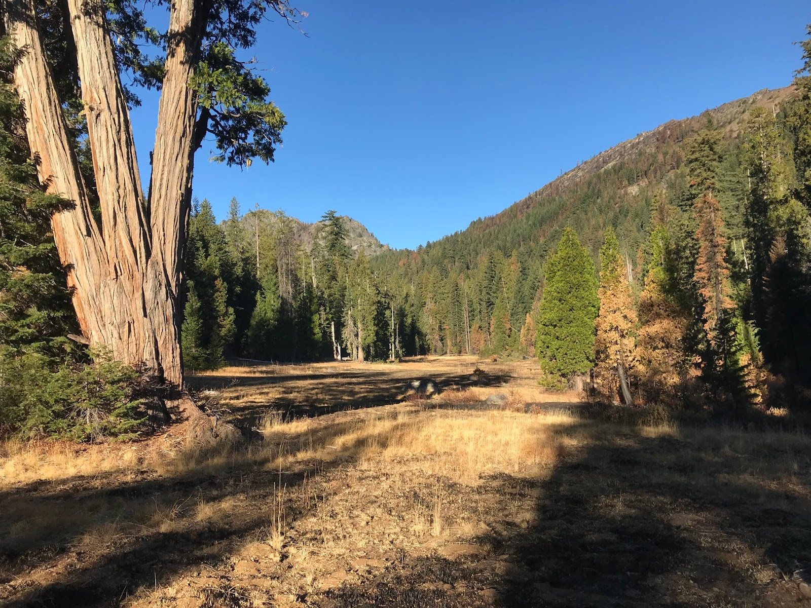
The Natchez Fire burned beautifully through Twin Valley and the surrounding watersheds in the Siskiyou Wilderness. The fire burned in a mixed severity fire mosaic, with mostly low to moderate fire effects. The wild and intact landscapes of the Siskiyou Wilderness are irreplaceable and should be protected for future generations, not bulldozed and degraded in firefighting operations far from homes or communities.

This article originally appeared on May 26, 2019 as a Guest Opinion piece in the Medford Mail Tribune

Monday, May 6, 2019

Klamath Forest Alliance Field Season

The snow pack is beginning to melt in the high country of the Siskiyou Crest.

With the snow beginning to melt in the high country, Klamath Forest Alliance (KFA) is preparing for our upcoming field season. Each season activists with KFA travel across the region monitoring federal land timber sales, grazing allotments, and illegal OHV trails. We roam the backcountry from the Pacific Coast to the interior mountains of the Klamath-Siskiyou. We drive bumpy backroads and hike hundreds of miles both on and off trail, through steep and rugged terrain. We climb mountains and traverse canyons to document proposed project activities and identify potential impacts associated with federal land management projects. 

Bolander's lily
We pack our supplies on our backs, often deep into the wilderness. We sleep on the ground and in the cold. We endure extreme heat, smoke-filled skies, electrical storms, and gully washing downpours. We trip, we fall, we sweat, we bleed; we are drilled by ticks, stung by ground nesting yellow jackets and eaten alive by mosquitoes. Yet, ultimately, we are also privileged to serve and defend the Klamath-Siskiyou! We are grateful for the time we spend in the field, defending the Klamath-Siskiyou and enjoying the region's spectacular beauty and diversity. The hardships endured build bonds with the land and the information gathered strengthens our advocacy. 
Recent post-fire monitoring in the Soda Mountain Wilderness revealed beautiful fire effects and spectacular vegetative recovery in the Scotch Creek Watershed. 

Our comprehensive monitoring programs give us intimate knowledge of proposed land management projects. The information gathered during on-the-ground monitoring activities informs our campaigns, outreach efforts, public comments, administrative appeals, and if necessary litigation. Our approach is science-based, site specific, comprehensive and effective. 

If you appreciate the work we do and the effort it takes, please consider making a generous donation to support our field monitoring season. We will crash through the poison oak and brave swarms of mosquitoes—all you have to do is click on this donation link and contribute a few bucks to be a part of the effort. 

Deep in the heart of the Marble Mountains Wilderness, the first snow fell on us while conducting fire monitoring for the 2014 Happy Camp Fire Report. Rain, snow or shine, KFA will be out defending our public lands!

At KFA, we think on-the-ground monitoring is one of the most important things we do. 


The Siskiyou Field Office of Klamath Forest Alliance will be conducting on-the-ground monitoring for the following federal land management activities in 2019:

Proposed Timber Sales:

  •  The Middle Applegate Timber Sale: The Middle Applegate Timber Sale is located in the Applegate Valley of southwestern Oregon on Medford District BLM land. The Wellington Butte Roadless Area (also known as Wellington Wildlands) is located within the planning area and KFA is concerned that the BLM may propose logging within the roadless area. The project is in pre-scoping and no formal proposal has currently been produced. KFA will be monitoring the proposed units as soon as they are identified.
  • The Briggs Creek Timber Sale: The Upper Briggs Project is located in Briggs Creek, a major tributary of the Illinois River and west of Grants Pass, Oregon. The entire timber sale burned in the 2018 Klondike-Taylor Fire, sustaining mostly low to moderate severity fire effects. Many timber sale units underburned at low severity, yet the agency tells us they are still at risk of "catastrophic fire." The agency has released a decision on this project and KFA is currently working on an Administrative Objection. We will also be conducting field monitoring to document fire effects and vegetative regeneration following the 2018 fires. 


Post-Implementation Monitoring:
  • The Seiad Horse Post-Fire Logging Project: This large post-fire logging project is located on the Klamath River above Seiad Valley, California on the Siskiyou Crest. The project proposes to clearcut forests affected by the 2017 Abney Fire. KFA and other conservation allies currently have portions of the project under an injunction and are litigating to stop the project from moving forward. Unfortunately, portions of the project were logged before an injunction could be secured and KFA will be monitoring those units to document the ecological impacts.
  •  Horse Creek Post-Fire Logging: The Horse Creek Project is located on the Klamath River above Horse Creek, California, also on the Siskiyou Creset. The project was implemented by the Klamath National Forest in 2017 and 2018, after the 2016 Gap Fire. KFA will be conducting post-implementation monitoring to document the ecological impacts.


OHV Monitoring:
  • OHV monitoring on the Rogue River-Siskiyou National Forest and Klamath National Forest: KFA will be working with conservation partners at Applegate Neighborhood Network to monitor OHV activity on the Siskiyou Crest and in designated Botanical Areas. Our monitoring activities will occur on the Klamath National Forest in northwestern California and on the Rogue River-Siskiyou National Forest in southwestern Oregon, and are used to advocate for closure of illegal and ecologically damaging OHV trails.
  •  OHV monitoring on the Medford District BLM: KFA will be working with conservation partners at Applegate Neigborhood Network to monitor OHV activity on the Medford District BLM, including within roadless areas, Lands with Wilderness Characteristics (LWC) and in biodiversity hotspots. Our mointoring is used to advocate for closure of damaging OHV trails.


Grazing Allotment Monitoring:
  • Siskiyou Crest Grazing Allotments: Along with our partners at the Grazing Reform Project, KFA will be conducting ongoing monitoring of grazing allotments on both the Klamath National Forest in northern California and the Rogue River-Siskiyou National Forest in southern Oregon. Our ongoing monitoring activities document environmental impacts associated with public land grazing. We use this information to advocate for reform of public land grazing practices and prepare for future updates to grazing plans on the Siskiyou Crest. 

Wildfire Monitoring

  • Klamath-Siskiyou Wildfire Monitoring: Each summer KFA monitors the wildfires burning in the Klamath-Siskiyou Mountains of northern California and southern Oregon. We monitor fire suppression activities, especially in roadless areas, wilderness areas, botanical areas and other important habitats. After the fires have been extinguished we explore the fires and their ecological effects. The information is used to advocate for the reform of fire suppression policy and strategy, as well as to publish detailed fire reports.


Help us put our best foot forward, donate to KFA! Even when sore, dirty and covered in soot from post-fire monitoring, we are happy to work for the Klamath-Siskiyou.