Wednesday, May 30, 2018

The Upper Briggs Restoration Project: Old forest logging proposed on Briggs Creek! Please comment now!

Old-growth forest proposed for logging in the Upper Briggs Restoration Project on the Secret Way Trail, south of Sam Brown Campground.
Upper Briggs Restoration Project: Old forest logging proposed on Briggs Creek! Please comment now, the comment period ends May 31st!

Briggs Creek is a beautiful stream flowing south into the Illinois River canyon from its headwaters near Onion Mountain Lookout, Taylor Mountain, and to the west, Chrome Ridge. The region contains steep forested slopes, gentle green meadows at Briggs Valley, serpentine ridges, and clear flowing streams. Briggs Creek is an important cold water tributary of the Illinois River with runs of coho salmon and steelhead trout. It is also an important recreation area just west of Grants Pass, Oregon with the world's tallest ponderosa pine trees.

The region has a rich human history of indigenous land management, and later, of mining, logging, ranching and recreation. The creek is named for George Briggs who packed supplies into the area for local miners with a team of mules. Starting in the late 1860s, the creek was heavily mined for gold. Most of the mining was taking place in the streams and fishery habitats on Briggs Creek and smaller tributaries. 

By the 1920s new roads led out to chromium mines on aptly named Chrome Ridge, and placer mining continued in the streams. Around this time settlers farmed and ranched the small meadows near Sam Brown Campground and Horse Creek Meadows. Later logging roads were built throughout the watershed and both clearcut and selective logging was common from the 1940s to the 1990s. Today, over 170 miles of road have been built within the Briggs Creek Watershed and roughly 7,000 acres have been clearcut by the Rogue River Siskiyou National Forest. 

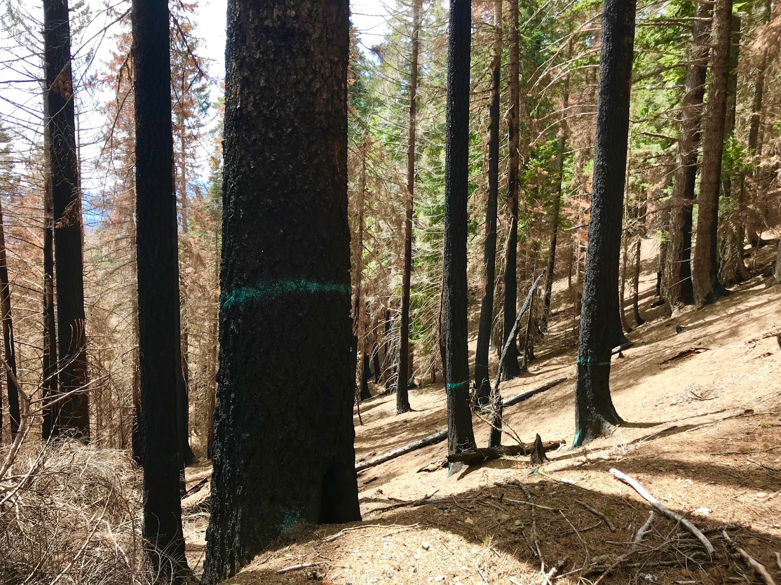
Old-growth forest proposed for logging to 40% canopy cover in unit 23 along the Secret Way Trail.
Although portions of the Briggs Creek Watershed have been badly damaged by mining, logging, road building and ranching, other portions remain as intact remnants of the once vast uncut forests, rocky, unroaded ridges, verdant meadows and clear salmon streams found on Briggs Creek.  

Since at least the 1960s the Forest Service has also managed numerous recreation sites in the Briggs Creek area, and generations of southern Oregon residents have fallen in love with the region for camping, hiking, and more recently, mountain biking.

The Sam Brown Campground and adjacent recreation sites continue to be extremely popular with area residents, and recently the Forest Service invested in maintenance, renovation and trail construction in a large, interconnected trail system leading from the Illinois River, up Briggs Creek and over the ridge to nearly the banks of the Rogue River on Taylor Creek.

A remnant grove of old Douglas fir trees growing in unit 35 of the Upper Briggs project. The stand is mostly mid-seral Douglas fir forest, but the agency has proposed to drastically reduce canopy cover, remove large trees and implement pine-oak restoration treatments. The proposal to convert Douglas fir forest to pine-oak structural conditions is inappropriate and will degrade forest habitats rather than "restore" them.

Unfortunately, the Forest Service has proposed the Upper Briggs Creek Restoration Project, a large landscape-scale timber sale that would log over 4,000 acres around the Sam Brown Campground, along recreational trails, in the Horse Creek Meadows Wildlife Area and in Critical Habitat for the Northern spotted owl. 

Klamath Forest Alliance has been monitoring proposed timber sale units and has prepared a detailed public comment advocating for old-growth forests, Northern spotted owl habitat and the protection of beautiful meadows in the Horse Creek Meadows Wildlife Area. 

We are especially concerned by the proposal to log old forest habitats and to conduct so-called "meadow restoration" treatments. 

Horse Creek Meadow Wildlife Area will be subjected to heavy industrial logging both in the meadow itself and in the forest surrounding the meadow.
The Forest Service is using aerial imagery from 1940 as a "reference ecosystem" despite eighty years of mining, logging, ranching and boom towns in the Briggs Creek watershed. They are using post-settlement era aerial photographs to define the extent of meadow habitats and have proposed to recreate them with "meadow restoration" treatments. The concept is that fire suppression has led to a decrease in meadow habitat due to conifer and shrub encroachment. Unfortunately, it was settlement and land clearing that may have accentuated these large meadows in the historic  photos. 

The supposed meadow restoration treatments proposed in the Upper Briggs Restoration Project would clearcut large swaths of forest adjacent to existing meadow habitats in the Horse Creek Meadows Wildlife Area and around Sam Brown Campground. The proposal also advocates logging all trees within the meadows that are less than 120 years old. 

Klamath Forest Alliance supports non-commercial meadow restoration measures that may include non-commercial thinning, prescribed fire, invasive plant removal, and native pollinator plant restoration. 

Beautiful old forest proposed for logging on the Secret Way Trail in unit 23B.
The project also includes units in beautiful, fire resistant, old-growth and late successional forest habitats on Myers Creek, Secret Creek, and Horse Creek. These forests contain important habitat for the Northern spotted owl and its primary prey source, the red tree vole. Some of the units also contain robust populations of the rare clustered lady's slipper (Cypripedium fasciculatum). Other units are located on popular recreational hiking, equestrian and mountain biking trails, including the Taylor Creek Trail, Onion Way Trail and Secret Way Trail. Logging these stands will degrade important late successional habitat, impact rare plant habitat, and damage beautiful recreational trails. 

What do you prefer? Camping and hiking among old-growth forests and beautiful mountain meadows, or stumpfields disguised as "restoration?"
These gorgeous meadows surrounding the Sam Brown Campground would be heavily logged in the Upper Briggs Restoration Project. The project calls for removing all trees less than 120 years old both in the meadow and in the forest at the meadow margin. According to Forest Service prescriptions, all conifers in this photograph would likely be removed. Leaving a stumpfield to surround the meadows and the campground.

Please consider commenting on the Upper Briggs Restoration Project Environmental Assessment. The comment period ends on May 31, 2018.

Send your comments to: 
comments-pacificnorthwest-siskiyou-wildrivers@fs.fed.us  
&
mpaciorek@fs.fed.us  

Upper Briggs Restoration Project Talking Points:
  • Cancel all proposed logging units in old-growth or late successional forest habitats including units 2, 9, 20, 21, 22, 23, 23b, 23c, 55 & 70.
  • Cancel logging units with large populations of the rare clustered lady's slipper orchid, including units 21 and 22. 
  • Do not implement meadow restoration that logs trees within or surrounding mountain meadows or campgrounds. Institute non-commercial meadow restoration treatments instead.
  • Do not approve the Red Tree Vole Habitat Conservation Plan and maintain all current protections for the red tree vole, including site protection measures and pre-disturbance surveys.
  • Do not downgrade Northern spotted owl habitat. 
  • Logging the Horse Creek Meadow Wildlife Area and Sam Brown Meadow in Meadow Restoration Treatments is inconsistent with the mandates of the Siskiyou National Forest Plan. 
  • Cancel all new road construction proposed in the Upper Briggs Restoration Project. 
  • Do not implement Oak-Pine Restoration Treatments in Douglas fir plant associations. The proposal will create novel forest conditions and is not restorative in nature.  

Wednesday, May 16, 2018

The Wellington Butte Roadless Area: A Wilderness at Our Backdoor

A view down the Balls Branch of Humbug Creek into the Applegate Valley.
The Wellington Butte Roadless Area is one of the most wild, spectacular, and threatened landscapes in the foothills of the Applegate Valley. It is also perhaps the most accessible wildland in the Applegate Watershed, with immense conservation and recreational opportunities

The region contains a diverse mosaic of plant communities, including sweeping grasslands, dense chaparral, sunlit oak woodlands, intact conifer forests and beautiful, mixed-hardwood stands dominated by madrone.
A flush of annual lupine blooming at the headwaters of the Balls Branch of Humbug Creek.
Spring has arrived in the Wellington Butte Roadless Area, and the slopes are currently ablaze with the colors of spring, buzzing with busy bees, fluttering butterflies, pollinating flies and beetles. Song birds chirp and sing, happily foraging for insects and seeds on the steep mountain slopes and in the brushy chaparral. Deer graze on the fresh grasses and black bear have awakened from their winter semi-hibernation. Lizards dart across the rocky outcrops and snakes slither through the grasslands eating insects, voles, and mice. It is a time of abundance and beauty in the Wellington Butte Roadless Area.

Spring wildflowers abound and fresh green oak leaves have emerged in the Balls Branch of Humbug Creek.
Although the scenery is pleasant and peaceful, the wildlife continue their seasonal patterns and wildflowers bloom as they have for millennia, the future of the Wellington Butte Roadless Area is uncertain. The wild landscape we know and love today could be lost forever.

The Wellington Butte Roadless Area was originally proposed for protection as a Land With Wilderness Characteristics (LWC) in the BLM's 2016 Draft Resource Management Plan (RMP). This designation would have provided minimal, but important interim protections and highlighted the area's wilderness qualities. 

Although the area met all the requirements for LWC designation and is one of the most well-known and well-loved wildlands in the Applegate Valley, the agency withdrew the area from consideration due to scattered stands of marketable timber among a vast mosaic of arid grassland, chaparral, oak woodland, mixed hardwood stands and dry, widely dispersed forest. The only real timber is located in the Deadhorse Fork of Balls Branch (a tributary of Humbug Creek) and Long Gulch, far from any roads, in deep canyons, riparian areas and north-facing slopes. 

The north-facing slopes and canyon bottom of the Deadhorse Fork is likely the largest concentration of uncut forest in the Wellington Butte Roadless Area.
Despite significant public support for protection of the Wellington Butte Roadless Area, the BLM has instead responded by opening portions of the area to off-road vehicle use, and is now proposing the massive Middle Applegate Timber Sale, in and around the Wellington Butte Roadless Area.

The Middle Applegate Timber Sale is a large, landscape-scale timber sale proposed by the Medford District BLM. Although the BLM has not yet released an official proposal, the planning area extends across the Middle Applegate watershed from Forest Creek in the east, to Slagle Creek on the west. As proposed, the timber sale could sprawl across the mountains of the Applegate Valley from the town of Ruch, to beyond the town of Applegate. At the center of the planning area is the Wellington Butte Roadless Area, and to date, BLM has refused to removed the area from consideration in the Middle Applegate Timber Sale. 
Beyond the large grasslands, on the north-facing slopes of Balls Branch and the Deadhorse Fork, is the largest concentration of forest in the Wellington Butte Roadless Area. Residents of the Applegate Valley and conservationists across southern Oregon urge the BLM to withdraw the Wellington Butte Roadless Area from the Middle Applegate Timber Sale.

The social and ecologic cost of removing timber from this area is extremely high, while the quality of timber and the regenerative capacity of the land in question is very low. It is abundantly clear that these wildlands and their minimal timber values are better suited for conservation than timber production, yet BLM pushes forward with plans to log some of the last intact landscapes in the Middle Applegate watershed.

 In early 2017 the Medford District BLM also approved a very controversial Categorical Exclusion (CE) — which means the public was "categorically" excluded from the decision making process — to provide defacto designation of 65 miles of previously unauthorized and illegally built off-road vehicle trails in the John's Peak OHV Area, including the Wellington Butte Roadless Area. They also approved the utilization of public funds and public agency crews or contractors to maintain off-road vehicle trails that have never received formal approval, are creating significant environmental impacts and have never been subjected to the NEPA process or public review. Despite over two decades of significant controversy surrounding the John's Peak OHV Area, the BLM made the decision without a public comment period or public review process. They simply did not want to hear what we had to say. 

The Medford District BLM is effectively encouraging illegal off-road vehicle trail creation and giving large tracks of land to off-road vehicle interests to utilize for their exclusive benefit, including the Wellington Butte Roadless Area. For decades, the BLM has turned a blind eye to unauthorized off-road vehicle activity and now they are codifying this unauthorized use and excluding the public from the process. The implications for the Wellington Butte Roadless Area are severe and eventually off-road vehicle trails could extend across the most remote portions of the region.
The spectacular wildflower fields of the Wellington Butte Roadless Area should be protected from off-road vehicle use.

If the BLM has their way, the Wellington Butte Roadless Area will be lost forever — the wild character replaced with logging roads, log landings, noxious weeds, stump fields and erosive dirt bike tracks.

Fortunately, residents in the area and local environmental organizations have begun tracking the Middle Applegate Timber Sale and are asking the BLM to remove the entire Wellington Butte Roadless Area from the planning area. We ask that the BLM remove the Wellington Butte Roadless Area from the planning area due to significant public controversy, incredible biological values, highly important low-elevation wildlife habitat, and marginal timber values. 

We also ask that the BLM rescind their recent Categorical Exclusion to allow maintenance of unauthorized  OHV trails in the Wellington Butte Roadless Area, and instead conduct Travel Management Planning as required in the 2016 RMP. 

Finally, Applegate Neighborhood Network, Klamath Forest Alliance and others in the conservation community are organizing a campaign to permanently protect the Wellington Butte Roadless Area. We believe the interim LWC designation should be extended to the entire 7,527 acre Roadless Area, creating the Wellington Butte Lands with Wilderness Characteristics. We also believe local advocates for the Wellington Butte Roadless Area should build a movement towards permanent Wilderness designation for the Applegate Foothills Wilderness, including its most threatened wildland: the Wellington Butte Roadless Area. 

Snowy or cobweb thistle (Cirsium occidentale) blooming on Balls Branch.
In all, nearly 50,000 acres of intact, roadless habitat exists in the foothills of the Applegate Valley. The wildlands are found scattered around the Applegate. They provide the scenic backdrop to our region; they provide incredible wildlife habitat and contain unique native plant communities, and they also provide highly important recreational opportunities in close proximity to nearby towns and communities. Additionally, the Wellington Butte Roadless Area will one day be traversed by the proposed Applegate Ridge Trail, providing highly accessible and highly scenic recreational opportunities for local hikers and equestrians.

We believe that the Applegate Foothills Wilderness should be protected in perpetuity. We also believe the protection of the Wellington Butte Roadless Area is the first step in this process. This uniquely accessible wildland, its scenic beauty and intact habitats are worth far more as they are. We will not let them become another BLM stumpfield riddled in off-road vehicle tracks. Please join us and advocate for the protection of the Wellington Butte Roadless Area!

The Wellington Butte Roadless Area should remain wild for generations to come.


Friday, May 11, 2018

Proposed Logging Along the PCT at Cook and Green Pass!

Proposed logging along the PCT at Cook and Green Pass. The hiker at the right-hand side of the photograph is hiking the PCT, and the Klamath National Forest is proposing to log directly into the trail corridor. Trees marked blue would be logged.
The Klamath National Forest has proposed a large, post-fire logging project in the 2017 Abney Fire footprint. The project would log over 1,200 acres of fire-affected forest in the region surrounding Cook and Green Pass. The project also proposes post-fire logging directly adjacent to the Pacific Crest Trail (PCT) and along the Bee Camp Road (47N80) in the Kangaroo Inventoried Roadless Area. 

Cook and Green Pass is the gateway to the Red Buttes Wilderness Area, the Kangaroo Inventoried Roadless Area and the Condrey Mountain Roadless Area, it is also located within a major connectivity corridor necessary for the dispersal of wildlife and native vegetation in the region — connecting the Marble Mountains and Klamath River area to the Siskiyou Mountains. The area is protected by multiple Botanical Areas and is thought to be one of the most diverse assemblages of native plants in all of California, with over 300 plant species documented. Many rare plant species can be found in the area, including Baker's cypress, Brewer's spruce, mountain lady slipper, splithair paintbrush, Newberry's gentian, Siskiyou fritillaria, Howell's lousewort, white flowered rein orchid and many others. The area contains many important biological values and should be protected for its own sake. It should also be protected for its important recreational values. 
Large, old trees marked for removal along the PCT at Cook and Green Pass.

Recently, the Klamath National Forest began marking timber along Bee Camp Road in a so-called roadside hazard logging unit. The proposal includes logging roughly two miles of Bee Camp Road, including portions of the Kangaroo Inventoried Roadless Area. Some of the logging will occur at Cook and Green Pass in old-growth forests that survived the Abney Fire. Both live trees and dead standing snags are marked for removal.

The logging would impact the Pacific Crest Trail by logging old-growth trees and snags within 30' of the trail and hundreds of feet on either side of Bee Camp Road. Currently, backcountry hikers heading west on the PCT at Cook and Green Pass enter the Kangaroo Inventoried Roadless Area in an isolated stand of old-growth forest before traversing the vast, red rock, serpentine barrens surrounding Red Butte. The experience is memorable and demonstrates the diversity of the Siskiyou Mountains, it will also be significantly degraded by old-growth roadside hazard logging.
 
A live, green tree marked for removal.

The Klamath National Forest's proposal to conduct "roadside hazard logging" on the PCT and in the Kangaroo Inventoried Roadless Area should be canceled. Bee Camp Road should be closed at Cook and Green Pass to protect connectivity, botanical resources, roadless values and recreational opportunities along the PCT. Close Bee Camp Road!

Please contact Forest Supervisor Patricia Grantham and ask her to cancel post-fire logging along Bee Camp Road (47N80) and close the road at Cook and Green Pass. 

Forest Supervisor Patricia Grantham: pagrantham@fs.fed.us

Complex, old-growth forest proposed for logging in the Kangaroo Inventoried Roadless Area and directly adjacent to the PCT at Cook and Green Pass.

Thursday, May 3, 2018

Miller Complex Fire Report: Mixed Severity Fire on the Siskiyou Crest

The Abney Fire burned through large portions of the Condrey Mountain and Kangaroo Inventoried Roadless Areas on the Siskiyou Crest in 2017.


The Klamath Forest Alliance has released the Miller Complex Fire Report, a detailed exploration of the Miller Complex Fire, its ecological implications, fire severity, and fire suppression impacts. 

The Miller Complex began on August 13, 2017 with a spectacular thunderstorm. Lightning crashed down throughout the Upper Applegate watershed, igniting 27 fires from the high country on the Siskiyou Crest to the low-elevation foothills of the Upper Applegate Valley. Four major blazes burned throughout the summer, including the Burnt Peak Fire, Creedence Fire, Abney Fire and Knox Fire. 

The fires burned in a healthy, mixed-severity fire mosaic, rejuvenating fire dependent plant communities, maintaining many late successional habitats, reducing fuel and restoring the process of fire to over 36,000 acres. Despite extensive efforts and significant environmental impacts associated with suppressing the Miller Complex, the Abney Fire was only extinguished by the first snow and rain in late October. 
The Abney Fire burned in a beneficial fire mosaic with highly variable fire effects.

Large portions of the Siskiyou Crest burned in a natural mixed-severity fire mosaic, including some of our wildest landscapes in the Red Buttes Wilderness Area, the Kangaroo Inventoried Roadless Area, Condrey Mountain Inventoried Roadless Area, Collings-Kinney Inventoried Roadless Area and the Stricklin Butte Roadless Area. 

The Miller Complex was a beautiful, diverse and rejuvenating natural event. The beneficial and highly variable fire mosaic will harbor extreme levels of biodiversity and fire resilience for many, many years to come. Fire is perhaps the most important natural process affecting terrestrial habitats in the Siskiyou Mountains, and the Miller Complex demonstrates the potential of managed wildfire as a restoration tool. 
Low-severity fire effects in the Collings-Kinney Roadless Area following the Burnt Peak Fire.


Please read our full Miller Complex Fire Report.